You are here: Home > Network List > EI - Irish National Seismic Network (INSN) Stations List
> Station VAL Valentia > Earthquake Result Viewer
VAL Valentia - Earthquake Result Viewer
| Earthquake location: |
East Of Kuril Islands |
| Earthquake latitude/longitude: |
49.0/157.7 |
| Earthquake time(UTC): |
2020/03/25 (085) 02:49:21 GMT |
| Earthquake Depth: |
57 km |
| Earthquake Magnitude: |
7.5 Mww |
| Earthquake Catalog/Contributor: |
NEIC PDE/us |
|
| Network: |
EI Irish National Seismic Network (INSN) |
| Station: |
VAL Valentia |
| Lat/Lon: |
51.94 N/10.24 W |
| Elevation: |
14 m |
|
| Distance: |
78.9 deg |
| Az: |
352.425 deg |
| Baz: |
8.064 deg |
| Ray Param: |
0.04920703 |
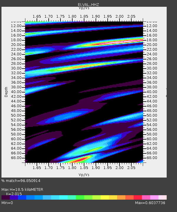
| Estimated Moho Depth: |
18.5 km |
| Estimated Crust Vp/Vs: |
2.02 |
| Assumed Crust Vp: |
6.24 km/s |
| Estimated Crust Vs: |
3.097 km/s |
| Estimated Crust Poisson's Ratio: |
0.34 |
|
| Radial Match: |
96.850914 % |
| Radial Bump: |
400 |
| Transverse Match: |
86.69857 % |
| Transverse Bump: |
400 |
| SOD ConfigId: |
20906531 |
| Insert Time: |
2020-04-08 14:58:55.921 +0000 |
| GWidth: |
2.5 |
| Max Bumps: |
400 |
| Tol: |
0.001 |
|

Signal To Noise
| Channel | StoN | STA | LTA |
| EI:VAL: :HHZ:20200325T03:00:47.729992Z | 7.673265 | 1.0449013E-5 | 1.3617428E-6 |
| EI:VAL: :HHN:20200325T03:00:47.729992Z | 5.7122602 | 4.3710825E-6 | 7.6521064E-7 |
| EI:VAL: :HHE:20200325T03:00:47.729992Z | 1.7609092 | 1.7415343E-6 | 9.889973E-7 |
| Arrivals |
| Ps | 3.1 SECOND |
| PpPs | 8.7 SECOND |
| PsPs/PpSs | 12 SECOND |


