You are here: Home > Network List > G - GEOSCOPE Stations List
> Station TAOE Taiohae, Marquises islands > Earthquake Result Viewer
TAOE Taiohae, Marquises islands - Earthquake Result Viewer
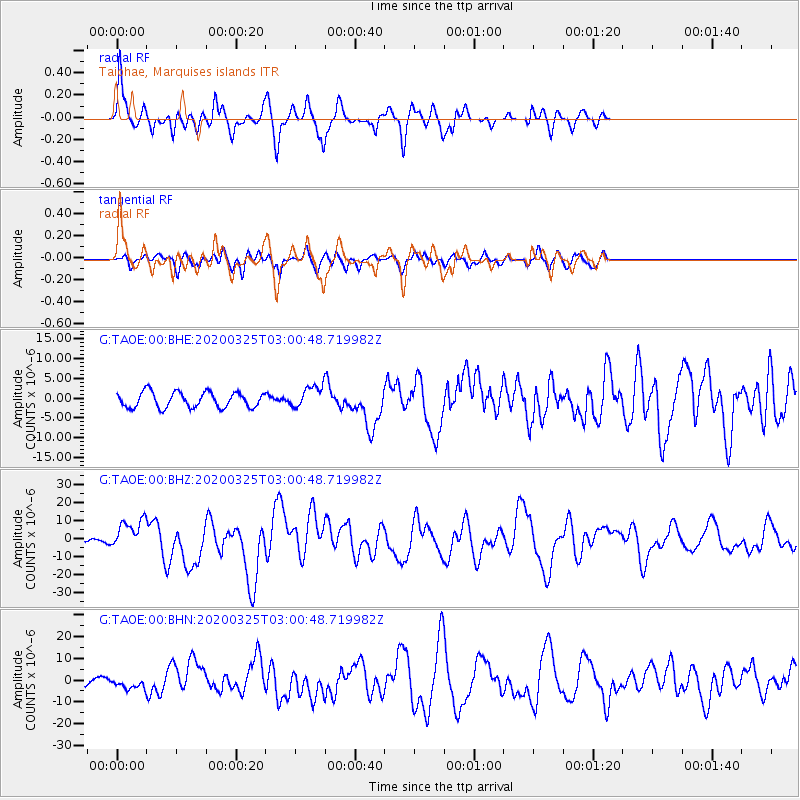
| Earthquake location: |
East Of Kuril Islands |
| Earthquake latitude/longitude: |
49.0/157.7 |
| Earthquake time(UTC): |
2020/03/25 (085) 02:49:21 GMT |
| Earthquake Depth: |
57 km |
| Earthquake Magnitude: |
7.5 Mww |
| Earthquake Catalog/Contributor: |
NEIC PDE/us |
|
| Network: |
G GEOSCOPE |
| Station: |
TAOE Taiohae, Marquises islands |
| Lat/Lon: |
8.85 S/140.15 W |
| Elevation: |
800 m |
|
| Distance: |
79.1 deg |
| Az: |
117.142 deg |
| Baz: |
323.617 deg |
| Ray Param: |
0.049085632 |
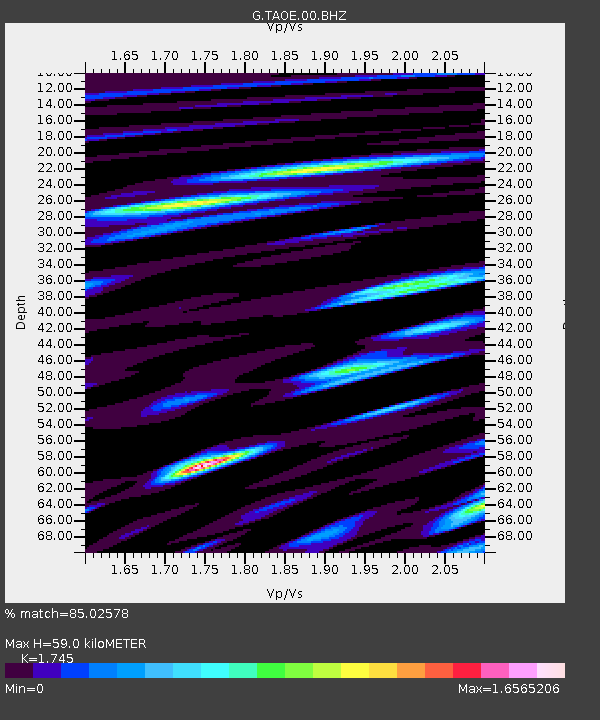
| Estimated Moho Depth: |
59.0 km |
| Estimated Crust Vp/Vs: |
1.75 |
| Assumed Crust Vp: |
4.24 km/s |
| Estimated Crust Vs: |
2.43 km/s |
| Estimated Crust Poisson's Ratio: |
0.26 |
|
| Radial Match: |
85.02578 % |
| Radial Bump: |
400 |
| Transverse Match: |
71.69387 % |
| Transverse Bump: |
400 |
| SOD ConfigId: |
20906531 |
| Insert Time: |
2020-04-08 14:59:17.969 +0000 |
| GWidth: |
2.5 |
| Max Bumps: |
400 |
| Tol: |
0.001 |
|
Signal To Noise
| Channel | StoN | STA | LTA |
| G:TAOE:00:BHZ:20200325T03:00:48.719982Z | 5.981455 | 8.243039E-6 | 1.3780993E-6 |
| G:TAOE:00:BHN:20200325T03:00:48.719982Z | 1.6401377 | 2.643558E-6 | 1.6117904E-6 |
| G:TAOE:00:BHE:20200325T03:00:48.719982Z | 1.4021591 | 2.729822E-6 | 1.9468705E-6 |
| Arrivals |
| Ps | 10 SECOND |
| PpPs | 38 SECOND |
| PsPs/PpSs | 48 SECOND |


