You are here: Home > Network List > GS - US Geological Survey Networks Stations List
> Station ALQ2 ASL Reference, STS-6 > Earthquake Result Viewer
ALQ2 ASL Reference, STS-6 - Earthquake Result Viewer
| Earthquake location: |
East Of Kuril Islands |
| Earthquake latitude/longitude: |
49.0/157.7 |
| Earthquake time(UTC): |
2020/03/25 (085) 02:49:21 GMT |
| Earthquake Depth: |
57 km |
| Earthquake Magnitude: |
7.5 Mww |
| Earthquake Catalog/Contributor: |
NEIC PDE/us |
|
| Network: |
GS US Geological Survey Networks |
| Station: |
ALQ2 ASL Reference, STS-6 |
| Lat/Lon: |
34.94 N/106.46 W |
| Elevation: |
1854 m |
|
| Distance: |
68.0 deg |
| Az: |
61.78 deg |
| Baz: |
315.046 deg |
| Ray Param: |
0.05643978 |
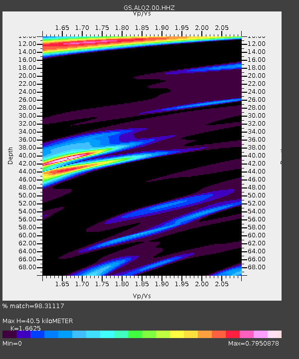
| Estimated Moho Depth: |
40.5 km |
| Estimated Crust Vp/Vs: |
1.66 |
| Assumed Crust Vp: |
6.502 km/s |
| Estimated Crust Vs: |
3.911 km/s |
| Estimated Crust Poisson's Ratio: |
0.22 |
|
| Radial Match: |
98.31117 % |
| Radial Bump: |
258 |
| Transverse Match: |
90.42802 % |
| Transverse Bump: |
400 |
| SOD ConfigId: |
20906531 |
| Insert Time: |
2020-04-08 15:00:35.872 +0000 |
| GWidth: |
2.5 |
| Max Bumps: |
400 |
| Tol: |
0.001 |
|

Signal To Noise
| Channel | StoN | STA | LTA |
| GS:ALQ2:00:HHZ:20200325T02:59:44.028027Z | 25.734167 | 9.75688E-6 | 3.7914108E-7 |
| GS:ALQ2:00:HH1:20200325T02:59:44.028027Z | 20.511086 | 3.1463621E-6 | 1.5339812E-7 |
| GS:ALQ2:00:HH2:20200325T02:59:44.028027Z | 18.655758 | 3.288227E-6 | 1.7625801E-7 |
| Arrivals |
| Ps | 4.3 SECOND |
| PpPs | 16 SECOND |
| PsPs/PpSs | 20 SECOND |


