You are here: Home > Network List > GS - US Geological Survey Networks Stations List
> Station KAN08 Pence Farm, Harper, KS, USA > Earthquake Result Viewer
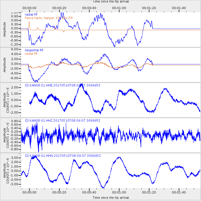
KAN08 Pence Farm, Harper, KS, USA - Earthquake Result Viewer
*The percent match for this event was below the threshold and hence no stack was calculated.
| Earthquake location: |
Andreanof Islands, Aleutian Is. |
| Earthquake latitude/longitude: |
51.4/-178.5 |
| Earthquake time(UTC): |
2017/05/10 (130) 07:59:55 GMT |
| Earthquake Depth: |
1.0 km |
| Earthquake Magnitude: |
6.0 Mi |
| Earthquake Catalog/Contributor: |
NEIC PDE/at |
|
| Network: |
GS US Geological Survey Networks |
| Station: |
KAN08 Pence Farm, Harper, KS, USA |
| Lat/Lon: |
37.23 N/97.97 W |
| Elevation: |
375 m |
|
| Distance: |
56.5 deg |
| Az: |
70.794 deg |
| Baz: |
312.226 deg |
| Ray Param: |
$rayparam |
*The percent match for this event was below the threshold and hence was not used in the summary stack. |
|
| Radial Match: |
61.404755 % |
| Radial Bump: |
400 |
| Transverse Match: |
80.12604 % |
| Transverse Bump: |
400 |
| SOD ConfigId: |
2028011 |
| Insert Time: |
2017-05-24 08:02:17.095 +0000 |
| GWidth: |
2.5 |
| Max Bumps: |
400 |
| Tol: |
0.001 |
|
Signal To Noise
| Channel | StoN | STA | LTA |
| GS:KAN08:01:HHZ:20170510T08:09:07.369995Z | 1.4774389 | 3.2930834E-7 | 2.2289133E-7 |
| GS:KAN08:01:HHN:20170510T08:09:07.369995Z | 3.795111 | 3.0590447E-6 | 8.0604883E-7 |
| GS:KAN08:01:HHE:20170510T08:09:07.369995Z | 2.1967838 | 1.5345297E-6 | 6.985347E-7 |
| Arrivals |
| Ps | |
| PpPs | |
| PsPs/PpSs | |


