You are here: Home > Network List > GS - US Geological Survey Networks Stations List
> Station DEC05 Apollo Drive Surface Site > Earthquake Result Viewer
DEC05 Apollo Drive Surface Site - Earthquake Result Viewer

| Earthquake location: |
East Of Kuril Islands |
| Earthquake latitude/longitude: |
49.0/157.7 |
| Earthquake time(UTC): |
2020/03/25 (085) 02:49:21 GMT |
| Earthquake Depth: |
57 km |
| Earthquake Magnitude: |
7.5 Mww |
| Earthquake Catalog/Contributor: |
NEIC PDE/us |
|
| Network: |
GS US Geological Survey Networks |
| Station: |
DEC05 Apollo Drive Surface Site |
| Lat/Lon: |
39.87 N/88.87 W |
| Elevation: |
216 m |
|
| Distance: |
73.8 deg |
| Az: |
47.327 deg |
| Baz: |
321.0 deg |
| Ray Param: |
0.052649446 |
| Estimated Moho Depth: |
50.75 km |
| Estimated Crust Vp/Vs: |
1.72 |
| Assumed Crust Vp: |
6.444 km/s |
| Estimated Crust Vs: |
3.752 km/s |
| Estimated Crust Poisson's Ratio: |
0.24 |
|
| Radial Match: |
97.909546 % |
| Radial Bump: |
321 |
| Transverse Match: |
94.7483 % |
| Transverse Bump: |
400 |
| SOD ConfigId: |
20906531 |
| Insert Time: |
2020-04-08 15:00:48.978 +0000 |
| GWidth: |
2.5 |
| Max Bumps: |
400 |
| Tol: |
0.001 |
|
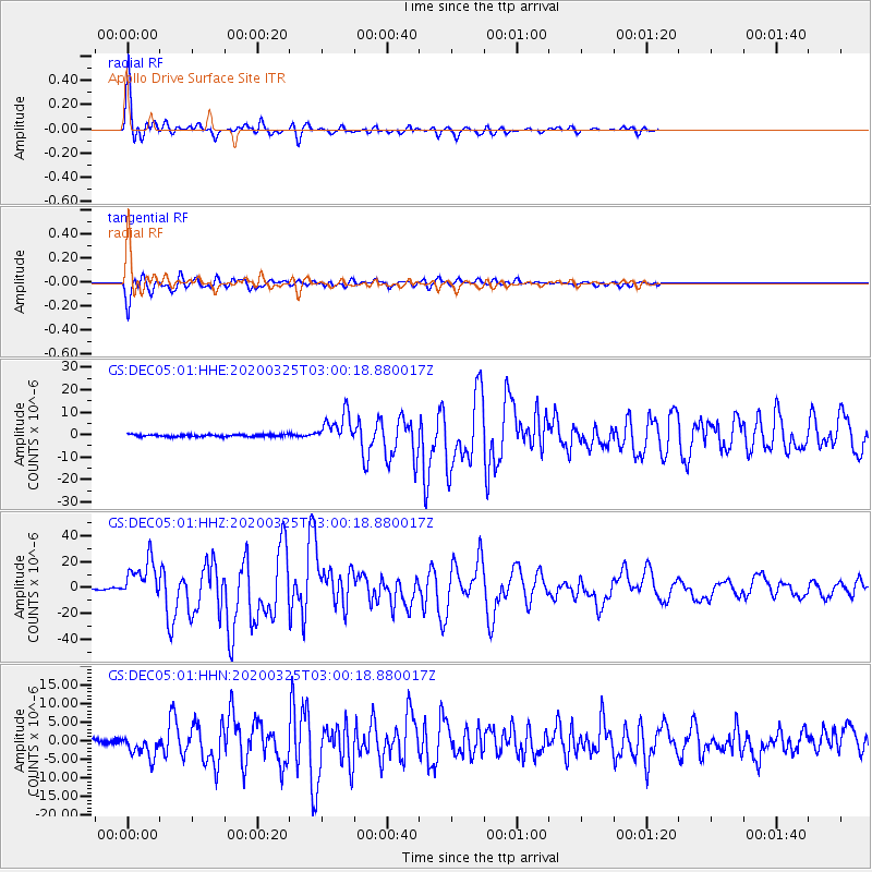
Signal To Noise
| Channel | StoN | STA | LTA |
| GS:DEC05:01:HHZ:20200325T03:00:18.880017Z | 51.72625 | 1.5479845E-5 | 2.9926483E-7 |
| GS:DEC05:01:HHN:20200325T03:00:18.880017Z | 5.9942856 | 3.1064721E-6 | 5.1823895E-7 |
| GS:DEC05:01:HHE:20200325T03:00:18.880017Z | 14.220626 | 6.6817474E-6 | 4.698631E-7 |
| Arrivals |
| Ps | 5.9 SECOND |
| PpPs | 21 SECOND |
| PsPs/PpSs | 27 SECOND |


