You are here: Home > Network List > HV - Hawaiian Volcano Observatory Network Stations List
> Station PUHI Puhimau Thermal Area > Earthquake Result Viewer
PUHI Puhimau Thermal Area - Earthquake Result Viewer
| Earthquake location: |
East Of Kuril Islands |
| Earthquake latitude/longitude: |
49.0/157.7 |
| Earthquake time(UTC): |
2020/03/25 (085) 02:49:21 GMT |
| Earthquake Depth: |
57 km |
| Earthquake Magnitude: |
7.5 Mww |
| Earthquake Catalog/Contributor: |
NEIC PDE/us |
|
| Network: |
HV Hawaiian Volcano Observatory Network |
| Station: |
PUHI Puhimau Thermal Area |
| Lat/Lon: |
19.39 N/155.25 W |
| Elevation: |
1079 m |
|
| Distance: |
47.8 deg |
| Az: |
111.092 deg |
| Baz: |
319.377 deg |
| Ray Param: |
0.069633275 |
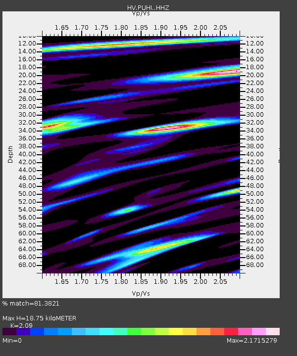
| Estimated Moho Depth: |
18.75 km |
| Estimated Crust Vp/Vs: |
2.09 |
| Assumed Crust Vp: |
5.195 km/s |
| Estimated Crust Vs: |
2.486 km/s |
| Estimated Crust Poisson's Ratio: |
0.35 |
|
| Radial Match: |
81.3821 % |
| Radial Bump: |
400 |
| Transverse Match: |
79.44276 % |
| Transverse Bump: |
400 |
| SOD ConfigId: |
20906531 |
| Insert Time: |
2020-04-08 15:01:31.737 +0000 |
| GWidth: |
2.5 |
| Max Bumps: |
400 |
| Tol: |
0.001 |
|

Signal To Noise
| Channel | StoN | STA | LTA |
| HV:PUHI: :HHZ:20200325T02:57:22.439007Z | 5.701857 | 4.6358296E-6 | 8.130385E-7 |
| HV:PUHI: :HHN:20200325T02:57:22.439007Z | 1.8849672 | 3.4243096E-6 | 1.8166414E-6 |
| HV:PUHI: :HHE:20200325T02:57:22.439007Z | 1.2718227 | 2.3852383E-6 | 1.8754488E-6 |
| Arrivals |
| Ps | 4.1 SECOND |
| PpPs | 11 SECOND |
| PsPs/PpSs | 15 SECOND |


