You are here: Home > Network List > IU - Global Seismograph Network (GSN - IRIS/USGS) Stations List
> Station KEV Kevo, Finland > Earthquake Result Viewer
KEV Kevo, Finland - Earthquake Result Viewer
| Earthquake location: |
East Of Kuril Islands |
| Earthquake latitude/longitude: |
49.0/157.7 |
| Earthquake time(UTC): |
2020/03/25 (085) 02:49:21 GMT |
| Earthquake Depth: |
57 km |
| Earthquake Magnitude: |
7.5 Mww |
| Earthquake Catalog/Contributor: |
NEIC PDE/us |
|
| Network: |
IU Global Seismograph Network (GSN - IRIS/USGS) |
| Station: |
KEV Kevo, Finland |
| Lat/Lon: |
69.76 N/27.00 E |
| Elevation: |
100 m |
|
| Distance: |
56.2 deg |
| Az: |
341.489 deg |
| Baz: |
36.932 deg |
| Ray Param: |
0.064138584 |
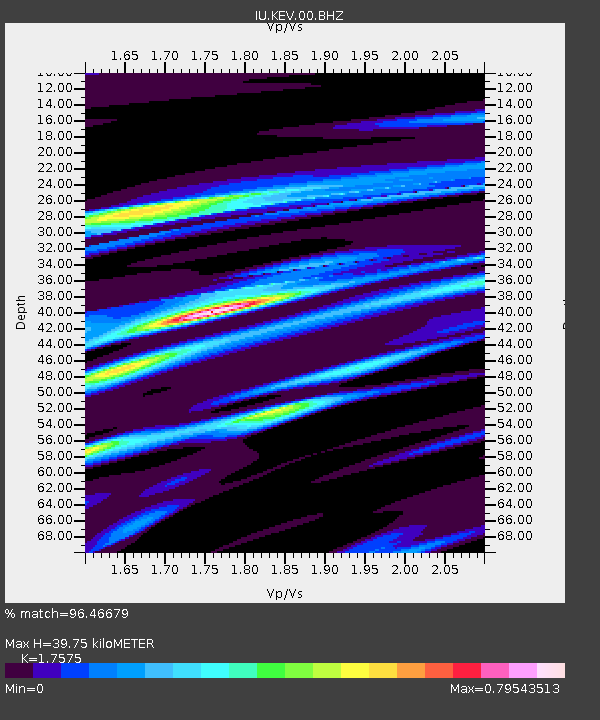
| Estimated Moho Depth: |
39.75 km |
| Estimated Crust Vp/Vs: |
1.76 |
| Assumed Crust Vp: |
6.622 km/s |
| Estimated Crust Vs: |
3.768 km/s |
| Estimated Crust Poisson's Ratio: |
0.26 |
|
| Radial Match: |
96.46679 % |
| Radial Bump: |
348 |
| Transverse Match: |
87.17624 % |
| Transverse Bump: |
400 |
| SOD ConfigId: |
20906531 |
| Insert Time: |
2020-04-08 15:02:35.921 +0000 |
| GWidth: |
2.5 |
| Max Bumps: |
400 |
| Tol: |
0.001 |
|
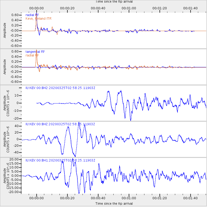
Signal To Noise
| Channel | StoN | STA | LTA |
| IU:KEV:00:BHZ:20200325T02:58:25.11903Z | 10.49331 | 8.493165E-6 | 8.0938855E-7 |
| IU:KEV:00:BH1:20200325T02:58:25.11903Z | 6.0917654 | 3.4025604E-6 | 5.585508E-7 |
| IU:KEV:00:BH2:20200325T02:58:25.11903Z | 5.1231894 | 3.2961834E-6 | 6.433851E-7 |
| Arrivals |
| Ps | 4.8 SECOND |
| PpPs | 16 SECOND |
| PsPs/PpSs | 20 SECOND |


