You are here: Home > Network List > IU - Global Seismograph Network (GSN - IRIS/USGS) Stations List
> Station RSSD Black Hills, South Dakota, USA > Earthquake Result Viewer
RSSD Black Hills, South Dakota, USA - Earthquake Result Viewer
| Earthquake location: |
East Of Kuril Islands |
| Earthquake latitude/longitude: |
49.0/157.7 |
| Earthquake time(UTC): |
2020/03/25 (085) 02:49:21 GMT |
| Earthquake Depth: |
57 km |
| Earthquake Magnitude: |
7.5 Mww |
| Earthquake Catalog/Contributor: |
NEIC PDE/us |
|
| Network: |
IU Global Seismograph Network (GSN - IRIS/USGS) |
| Station: |
RSSD Black Hills, South Dakota, USA |
| Lat/Lon: |
44.12 N/104.04 W |
| Elevation: |
2090 m |
|
| Distance: |
63.0 deg |
| Az: |
53.108 deg |
| Baz: |
312.986 deg |
| Ray Param: |
0.059725598 |
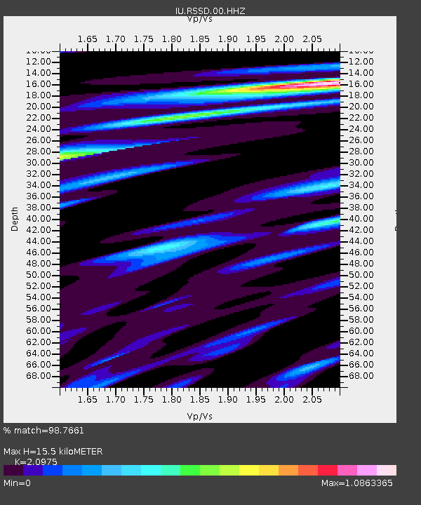
| Estimated Moho Depth: |
15.5 km |
| Estimated Crust Vp/Vs: |
2.10 |
| Assumed Crust Vp: |
6.242 km/s |
| Estimated Crust Vs: |
2.976 km/s |
| Estimated Crust Poisson's Ratio: |
0.35 |
|
| Radial Match: |
98.7661 % |
| Radial Bump: |
319 |
| Transverse Match: |
93.09746 % |
| Transverse Bump: |
400 |
| SOD ConfigId: |
20906531 |
| Insert Time: |
2020-04-08 15:02:47.355 +0000 |
| GWidth: |
2.5 |
| Max Bumps: |
400 |
| Tol: |
0.001 |
|

Signal To Noise
| Channel | StoN | STA | LTA |
| IU:RSSD:00:HHZ:20200325T02:59:11.648022Z | 42.677166 | 1.5358004E-5 | 3.5986469E-7 |
| IU:RSSD:00:HH1:20200325T02:59:11.648022Z | 13.703627 | 2.0233795E-6 | 1.4765286E-7 |
| IU:RSSD:00:HH2:20200325T02:59:11.648022Z | 30.960165 | 7.626481E-6 | 2.4633206E-7 |
| Arrivals |
| Ps | 2.8 SECOND |
| PpPs | 7.4 SECOND |
| PsPs/PpSs | 10 SECOND |


