You are here: Home > Network List > KR - Kyrgyz Digital Network Stations List
> Station TRKS Terek-Say, Kyrgyzstan > Earthquake Result Viewer
TRKS Terek-Say, Kyrgyzstan - Earthquake Result Viewer
| Earthquake location: |
East Of Kuril Islands |
| Earthquake latitude/longitude: |
49.0/157.7 |
| Earthquake time(UTC): |
2020/03/25 (085) 02:49:21 GMT |
| Earthquake Depth: |
57 km |
| Earthquake Magnitude: |
7.5 Mww |
| Earthquake Catalog/Contributor: |
NEIC PDE/us |
|
| Network: |
KR Kyrgyz Digital Network |
| Station: |
TRKS Terek-Say, Kyrgyzstan |
| Lat/Lon: |
41.46 N/71.17 E |
| Elevation: |
1518 m |
|
| Distance: |
58.2 deg |
| Az: |
298.078 deg |
| Baz: |
50.652 deg |
| Ray Param: |
0.062826626 |
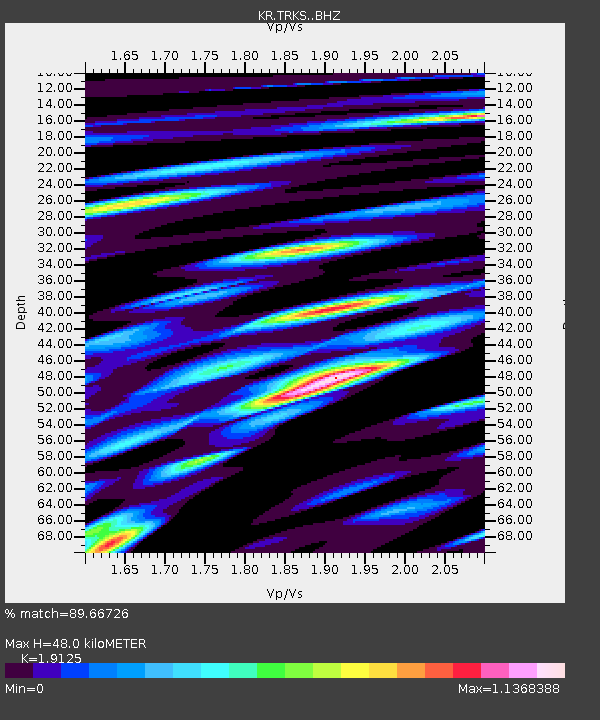
| Estimated Moho Depth: |
48.0 km |
| Estimated Crust Vp/Vs: |
1.91 |
| Assumed Crust Vp: |
6.236 km/s |
| Estimated Crust Vs: |
3.261 km/s |
| Estimated Crust Poisson's Ratio: |
0.31 |
|
| Radial Match: |
89.66726 % |
| Radial Bump: |
400 |
| Transverse Match: |
85.317894 % |
| Transverse Bump: |
400 |
| SOD ConfigId: |
20906531 |
| Insert Time: |
2020-04-08 15:03:52.177 +0000 |
| GWidth: |
2.5 |
| Max Bumps: |
400 |
| Tol: |
0.001 |
|

Signal To Noise
| Channel | StoN | STA | LTA |
| KR:TRKS: :BHZ:20200325T02:58:39.240002Z | 19.020597 | 3.6484987E-6 | 1.918183E-7 |
| KR:TRKS: :BHN:20200325T02:58:39.240002Z | 3.8204136 | 7.4586006E-7 | 1.9523019E-7 |
| KR:TRKS: :BHE:20200325T02:58:39.240002Z | 11.561192 | 1.5340092E-6 | 1.3268608E-7 |
| Arrivals |
| Ps | 7.3 SECOND |
| PpPs | 21 SECOND |
| PsPs/PpSs | 29 SECOND |


