You are here: Home > Network List > GS - US Geological Survey Networks Stations List
> Station OK031 S. Brethren Rd., Cushing, OK, USA > Earthquake Result Viewer
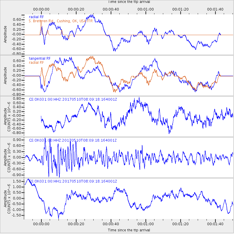
OK031 S. Brethren Rd., Cushing, OK, USA - Earthquake Result Viewer
*The percent match for this event was below the threshold and hence no stack was calculated.
| Earthquake location: |
Andreanof Islands, Aleutian Is. |
| Earthquake latitude/longitude: |
51.4/-178.5 |
| Earthquake time(UTC): |
2017/05/10 (130) 07:59:55 GMT |
| Earthquake Depth: |
1.0 km |
| Earthquake Magnitude: |
6.0 Mi |
| Earthquake Catalog/Contributor: |
NEIC PDE/at |
|
| Network: |
GS US Geological Survey Networks |
| Station: |
OK031 S. Brethren Rd., Cushing, OK, USA |
| Lat/Lon: |
35.95 N/96.84 W |
| Elevation: |
290 m |
|
| Distance: |
58.0 deg |
| Az: |
71.172 deg |
| Baz: |
313.102 deg |
| Ray Param: |
$rayparam |
*The percent match for this event was below the threshold and hence was not used in the summary stack. |
|
| Radial Match: |
31.782415 % |
| Radial Bump: |
400 |
| Transverse Match: |
25.155941 % |
| Transverse Bump: |
400 |
| SOD ConfigId: |
2028011 |
| Insert Time: |
2017-05-24 08:02:41.451 +0000 |
| GWidth: |
2.5 |
| Max Bumps: |
400 |
| Tol: |
0.001 |
|
Signal To Noise
| Channel | StoN | STA | LTA |
| GS:OK031:00:HHZ:20170510T08:09:18.164001Z | 4.348176 | 4.345158E-7 | 9.9930595E-8 |
| GS:OK031:00:HH1:20170510T08:09:18.164001Z | 0.8893093 | 9.537031E-7 | 1.0724087E-6 |
| GS:OK031:00:HH2:20170510T08:09:18.164001Z | 1.394029 | 4.4021937E-7 | 3.1578924E-7 |
| Arrivals |
| Ps | |
| PpPs | |
| PsPs/PpSs | |


