You are here: Home > Network List > MB - Montana Regional Seismic Network Stations List
> Station LDM Little Jackson Creek seismic vault > Earthquake Result Viewer
LDM Little Jackson Creek seismic vault - Earthquake Result Viewer
| Earthquake location: |
East Of Kuril Islands |
| Earthquake latitude/longitude: |
49.0/157.7 |
| Earthquake time(UTC): |
2020/03/25 (085) 02:49:21 GMT |
| Earthquake Depth: |
57 km |
| Earthquake Magnitude: |
7.5 Mww |
| Earthquake Catalog/Contributor: |
NEIC PDE/us |
|
| Network: |
MB Montana Regional Seismic Network |
| Station: |
LDM Little Jackson Creek seismic vault |
| Lat/Lon: |
48.45 N/115.32 W |
| Elevation: |
840 m |
|
| Distance: |
54.2 deg |
| Az: |
55.015 deg |
| Baz: |
305.833 deg |
| Ray Param: |
0.06544495 |
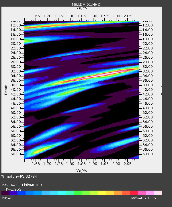
| Estimated Moho Depth: |
33.0 km |
| Estimated Crust Vp/Vs: |
1.96 |
| Assumed Crust Vp: |
6.622 km/s |
| Estimated Crust Vs: |
3.387 km/s |
| Estimated Crust Poisson's Ratio: |
0.32 |
|
| Radial Match: |
95.62734 % |
| Radial Bump: |
400 |
| Transverse Match: |
91.00319 % |
| Transverse Bump: |
400 |
| SOD ConfigId: |
20906531 |
| Insert Time: |
2020-04-08 15:04:53.482 +0000 |
| GWidth: |
2.5 |
| Max Bumps: |
400 |
| Tol: |
0.001 |
|

Signal To Noise
| Channel | StoN | STA | LTA |
| MB:LDM:01:HHZ:20200325T02:58:10.740002Z | 79.348076 | 1.7638675E-5 | 2.2229494E-7 |
| MB:LDM:01:HHN:20200325T02:58:10.740002Z | 7.8203917 | 2.7402887E-6 | 3.5040298E-7 |
| MB:LDM:01:HHE:20200325T02:58:10.740002Z | 32.095055 | 8.754711E-6 | 2.7277446E-7 |
| Arrivals |
| Ps | 5.0 SECOND |
| PpPs | 14 SECOND |
| PsPs/PpSs | 19 SECOND |


