You are here: Home > Network List > TS - TERRAscope (Southern California Seismic Network) Stations List
> Station RPV Rancho Palos Verde California, USA > Earthquake Result Viewer
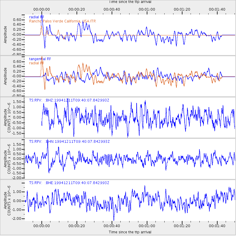
RPV Rancho Palos Verde California, USA - Earthquake Result Viewer
*The percent match for this event was below the threshold and hence no stack was calculated.
| Earthquake location: |
South Of Fiji Islands |
| Earthquake latitude/longitude: |
-24.9/-179.1 |
| Earthquake time(UTC): |
1994/12/11 (345) 09:29:01 GMT |
| Earthquake Depth: |
391 km |
| Earthquake Magnitude: |
5.5 MB, 5.6 UNKNOWN |
| Earthquake Catalog/Contributor: |
WHDF/NEIC |
|
| Network: |
TS TERRAscope (Southern California Seismic Network) |
| Station: |
RPV Rancho Palos Verde California, USA |
| Lat/Lon: |
33.74 N/118.40 W |
| Elevation: |
115 m |
|
| Distance: |
82.0 deg |
| Az: |
47.21 deg |
| Baz: |
233.115 deg |
| Ray Param: |
$rayparam |
*The percent match for this event was below the threshold and hence was not used in the summary stack. |
|
| Radial Match: |
51.01286 % |
| Radial Bump: |
400 |
| Transverse Match: |
36.804794 % |
| Transverse Bump: |
400 |
| SOD ConfigId: |
4480 |
| Insert Time: |
2010-02-26 14:45:31.317 +0000 |
| GWidth: |
2.5 |
| Max Bumps: |
400 |
| Tol: |
0.001 |
|
Signal To Noise
| Channel | StoN | STA | LTA |
| TS:RPV: :BHN:19941211T09:40:07.842993Z | 2.7607055 | 7.764817E-7 | 2.8126206E-7 |
| TS:RPV: :BHE:19941211T09:40:07.842993Z | 0.8649234 | 5.076177E-7 | 5.8689324E-7 |
| TS:RPV: :BHZ:19941211T09:40:07.842993Z | 0.97681534 | 6.827307E-7 | 6.9893525E-7 |
| Arrivals |
| Ps | |
| PpPs | |
| PsPs/PpSs | |


