You are here: Home > Network List > N4 - Central and EAstern US Network Stations List
> Station 152A Waverly Hall, GA, USA > Earthquake Result Viewer
152A Waverly Hall, GA, USA - Earthquake Result Viewer
| Earthquake location: |
East Of Kuril Islands |
| Earthquake latitude/longitude: |
49.0/157.7 |
| Earthquake time(UTC): |
2020/03/25 (085) 02:49:21 GMT |
| Earthquake Depth: |
57 km |
| Earthquake Magnitude: |
7.5 Mww |
| Earthquake Catalog/Contributor: |
NEIC PDE/us |
|
| Network: |
N4 Central and EAstern US Network |
| Station: |
152A Waverly Hall, GA, USA |
| Lat/Lon: |
32.67 N/84.72 W |
| Elevation: |
214 m |
|
| Distance: |
81.6 deg |
| Az: |
49.09 deg |
| Baz: |
323.825 deg |
| Ray Param: |
0.04740378 |
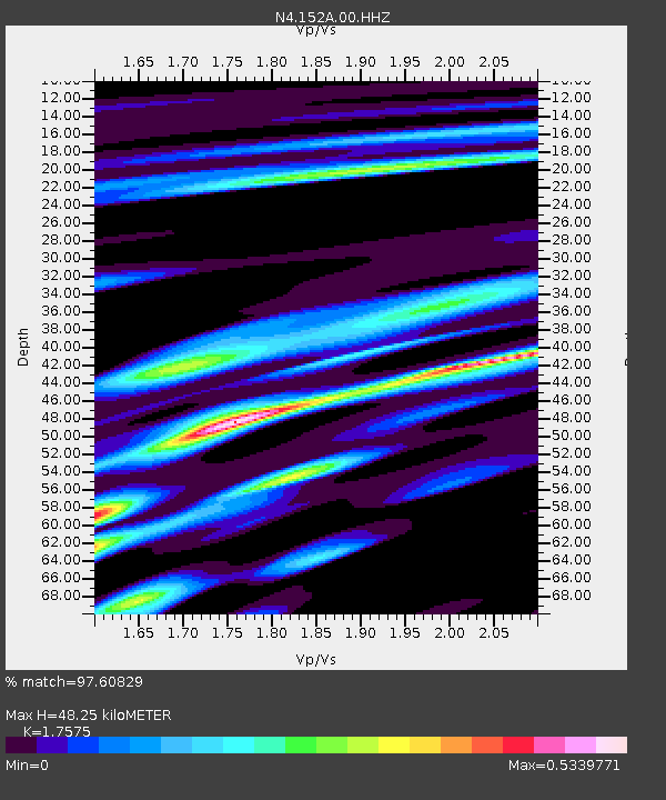
| Estimated Moho Depth: |
48.25 km |
| Estimated Crust Vp/Vs: |
1.76 |
| Assumed Crust Vp: |
6.719 km/s |
| Estimated Crust Vs: |
3.823 km/s |
| Estimated Crust Poisson's Ratio: |
0.26 |
|
| Radial Match: |
97.60829 % |
| Radial Bump: |
285 |
| Transverse Match: |
78.11312 % |
| Transverse Bump: |
400 |
| SOD ConfigId: |
20906531 |
| Insert Time: |
2020-04-08 15:05:32.163 +0000 |
| GWidth: |
2.5 |
| Max Bumps: |
400 |
| Tol: |
0.001 |
|

Signal To Noise
| Channel | StoN | STA | LTA |
| N4:152A:00:HHZ:20200325T03:01:01.800Z | 55.03886 | 1.2661189E-5 | 2.3004091E-7 |
| N4:152A:00:HH1:20200325T03:01:01.800Z | 17.053846 | 3.7335706E-6 | 2.1892836E-7 |
| N4:152A:00:HH2:20200325T03:01:01.800Z | 15.7695675 | 2.9062244E-6 | 1.8429321E-7 |
| Arrivals |
| Ps | 5.6 SECOND |
| PpPs | 19 SECOND |
| PsPs/PpSs | 25 SECOND |


