You are here: Home > Network List > N4 - Central and EAstern US Network Stations List
> Station ABTX Abilene, Hawley, TX, USA > Earthquake Result Viewer
ABTX Abilene, Hawley, TX, USA - Earthquake Result Viewer
| Earthquake location: |
East Of Kuril Islands |
| Earthquake latitude/longitude: |
49.0/157.7 |
| Earthquake time(UTC): |
2020/03/25 (085) 02:49:21 GMT |
| Earthquake Depth: |
57 km |
| Earthquake Magnitude: |
7.5 Mww |
| Earthquake Catalog/Contributor: |
NEIC PDE/us |
|
| Network: |
N4 Central and EAstern US Network |
| Station: |
ABTX Abilene, Hawley, TX, USA |
| Lat/Lon: |
32.62 N/99.64 W |
| Elevation: |
502 m |
|
| Distance: |
73.6 deg |
| Az: |
59.106 deg |
| Baz: |
317.943 deg |
| Ray Param: |
0.0527691 |
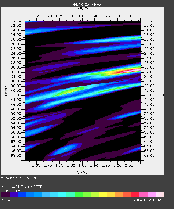
| Estimated Moho Depth: |
31.0 km |
| Estimated Crust Vp/Vs: |
2.08 |
| Assumed Crust Vp: |
6.426 km/s |
| Estimated Crust Vs: |
3.097 km/s |
| Estimated Crust Poisson's Ratio: |
0.35 |
|
| Radial Match: |
98.74076 % |
| Radial Bump: |
246 |
| Transverse Match: |
95.24336 % |
| Transverse Bump: |
400 |
| SOD ConfigId: |
20906531 |
| Insert Time: |
2020-04-08 15:05:44.461 +0000 |
| GWidth: |
2.5 |
| Max Bumps: |
400 |
| Tol: |
0.001 |
|

Signal To Noise
| Channel | StoN | STA | LTA |
| N4:ABTX:00:HHZ:20200325T03:00:17.799023Z | 75.73857 | 1.5276259E-5 | 2.0169722E-7 |
| N4:ABTX:00:HH1:20200325T03:00:17.799023Z | 29.004879 | 4.48753E-6 | 1.5471637E-7 |
| N4:ABTX:00:HH2:20200325T03:00:17.799023Z | 27.961823 | 4.009727E-6 | 1.4340006E-7 |
| Arrivals |
| Ps | 5.3 SECOND |
| PpPs | 14 SECOND |
| PsPs/PpSs | 20 SECOND |


