You are here: Home > Network List > N4 - Central and EAstern US Network Stations List
> Station I37B Waseca, MN, USA > Earthquake Result Viewer
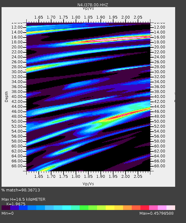
I37B Waseca, MN, USA - Earthquake Result Viewer
| Earthquake location: |
East Of Kuril Islands |
| Earthquake latitude/longitude: |
49.0/157.7 |
| Earthquake time(UTC): |
2020/03/25 (085) 02:49:21 GMT |
| Earthquake Depth: |
57 km |
| Earthquake Magnitude: |
7.5 Mww |
| Earthquake Catalog/Contributor: |
NEIC PDE/us |
|
| Network: |
N4 Central and EAstern US Network |
| Station: |
I37B Waseca, MN, USA |
| Lat/Lon: |
44.01 N/93.40 W |
| Elevation: |
354 m |
|
| Distance: |
68.5 deg |
| Az: |
47.202 deg |
| Baz: |
317.937 deg |
| Ray Param: |
0.056166958 |
| Estimated Moho Depth: |
16.5 km |
| Estimated Crust Vp/Vs: |
1.97 |
| Assumed Crust Vp: |
6.571 km/s |
| Estimated Crust Vs: |
3.34 km/s |
| Estimated Crust Poisson's Ratio: |
0.33 |
|
| Radial Match: |
98.36713 % |
| Radial Bump: |
400 |
| Transverse Match: |
92.72093 % |
| Transverse Bump: |
400 |
| SOD ConfigId: |
20906531 |
| Insert Time: |
2020-04-08 15:06:04.493 +0000 |
| GWidth: |
2.5 |
| Max Bumps: |
400 |
| Tol: |
0.001 |
|

Signal To Noise
| Channel | StoN | STA | LTA |
| N4:I37B:00:HHZ:20200325T02:59:46.669018Z | 46.500416 | 1.9392406E-5 | 4.1703728E-7 |
| N4:I37B:00:HH1:20200325T02:59:46.669018Z | 5.037186 | 5.530938E-6 | 1.0980212E-6 |
| N4:I37B:00:HH2:20200325T02:59:46.669018Z | 12.828711 | 5.7049097E-6 | 4.446986E-7 |
| Arrivals |
| Ps | 2.5 SECOND |
| PpPs | 7.2 SECOND |
| PsPs/PpSs | 9.7 SECOND |


