You are here: Home > Network List > N4 - Central and EAstern US Network Stations List
> Station M50A Fremont, OH, USA > Earthquake Result Viewer
M50A Fremont, OH, USA - Earthquake Result Viewer
| Earthquake location: |
East Of Kuril Islands |
| Earthquake latitude/longitude: |
49.0/157.7 |
| Earthquake time(UTC): |
2020/03/25 (085) 02:49:21 GMT |
| Earthquake Depth: |
57 km |
| Earthquake Magnitude: |
7.5 Mww |
| Earthquake Catalog/Contributor: |
NEIC PDE/us |
|
| Network: |
N4 Central and EAstern US Network |
| Station: |
M50A Fremont, OH, USA |
| Lat/Lon: |
41.40 N/83.04 W |
| Elevation: |
176 m |
|
| Distance: |
75.3 deg |
| Az: |
42.72 deg |
| Baz: |
323.553 deg |
| Ray Param: |
0.051644597 |
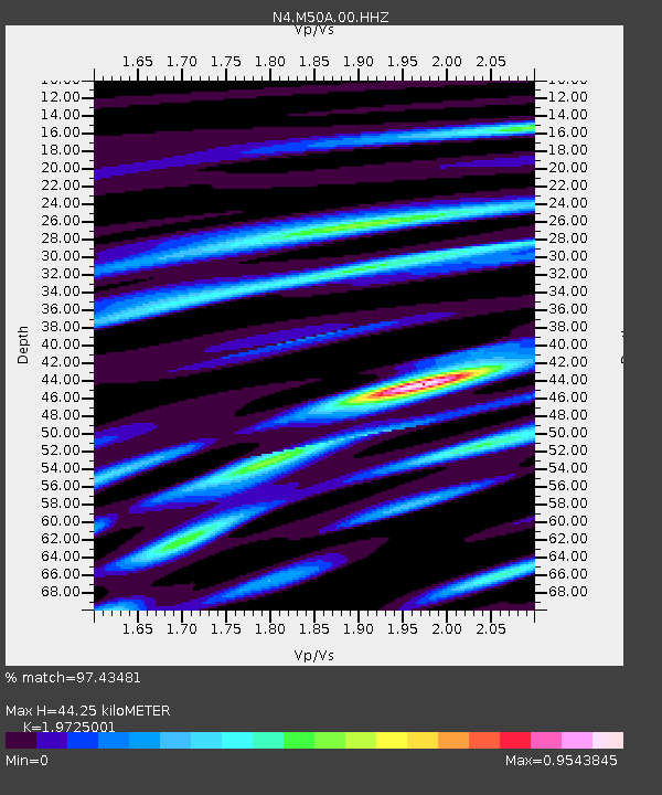
| Estimated Moho Depth: |
44.25 km |
| Estimated Crust Vp/Vs: |
1.97 |
| Assumed Crust Vp: |
6.498 km/s |
| Estimated Crust Vs: |
3.294 km/s |
| Estimated Crust Poisson's Ratio: |
0.33 |
|
| Radial Match: |
97.43481 % |
| Radial Bump: |
291 |
| Transverse Match: |
91.68132 % |
| Transverse Bump: |
400 |
| SOD ConfigId: |
20906531 |
| Insert Time: |
2020-04-08 15:06:45.344 +0000 |
| GWidth: |
2.5 |
| Max Bumps: |
400 |
| Tol: |
0.001 |
|

Signal To Noise
| Channel | StoN | STA | LTA |
| N4:M50A:00:HHZ:20200325T03:00:27.560009Z | 19.453798 | 1.30118215E-5 | 6.688576E-7 |
| N4:M50A:00:HH1:20200325T03:00:27.560009Z | 16.754251 | 4.4169706E-6 | 2.636328E-7 |
| N4:M50A:00:HH2:20200325T03:00:27.560009Z | 6.4712467 | 2.8233894E-6 | 4.362976E-7 |
| Arrivals |
| Ps | 6.8 SECOND |
| PpPs | 20 SECOND |
| PsPs/PpSs | 26 SECOND |


