You are here: Home > Network List > NM - Cooperative New Madrid Seismic Network Stations List
> Station LNXT Lenox,TN > Earthquake Result Viewer
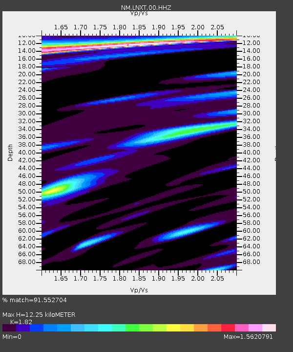
LNXT Lenox,TN - Earthquake Result Viewer
| Earthquake location: |
East Of Kuril Islands |
| Earthquake latitude/longitude: |
49.0/157.7 |
| Earthquake time(UTC): |
2020/03/25 (085) 02:49:21 GMT |
| Earthquake Depth: |
57 km |
| Earthquake Magnitude: |
7.5 Mww |
| Earthquake Catalog/Contributor: |
NEIC PDE/us |
|
| Network: |
NM Cooperative New Madrid Seismic Network |
| Station: |
LNXT Lenox,TN |
| Lat/Lon: |
36.10 N/89.49 W |
| Elevation: |
144 m |
|
| Distance: |
76.4 deg |
| Az: |
50.166 deg |
| Baz: |
321.346 deg |
| Ray Param: |
0.050890867 |
| Estimated Moho Depth: |
12.25 km |
| Estimated Crust Vp/Vs: |
1.82 |
| Assumed Crust Vp: |
6.444 km/s |
| Estimated Crust Vs: |
3.541 km/s |
| Estimated Crust Poisson's Ratio: |
0.28 |
|
| Radial Match: |
91.552704 % |
| Radial Bump: |
266 |
| Transverse Match: |
85.99758 % |
| Transverse Bump: |
270 |
| SOD ConfigId: |
20906531 |
| Insert Time: |
2020-04-08 15:09:03.674 +0000 |
| GWidth: |
2.5 |
| Max Bumps: |
400 |
| Tol: |
0.001 |
|

Signal To Noise
| Channel | StoN | STA | LTA |
| NM:LNXT:00:HHZ:20200325T03:00:33.930004Z | 40.919067 | 1.8606279E-5 | 4.5470927E-7 |
| NM:LNXT:00:HHN:20200325T03:00:33.930004Z | 3.628653 | 5.060596E-6 | 1.394621E-6 |
| NM:LNXT:00:HHE:20200325T03:00:33.930004Z | 1.994576 | 4.138899E-6 | 2.0750772E-6 |
| Arrivals |
| Ps | 1.6 SECOND |
| PpPs | 5.2 SECOND |
| PsPs/PpSs | 6.8 SECOND |


