You are here: Home > Network List > NM - Cooperative New Madrid Seismic Network Stations List
> Station LPAR Lepanto,AR > Earthquake Result Viewer
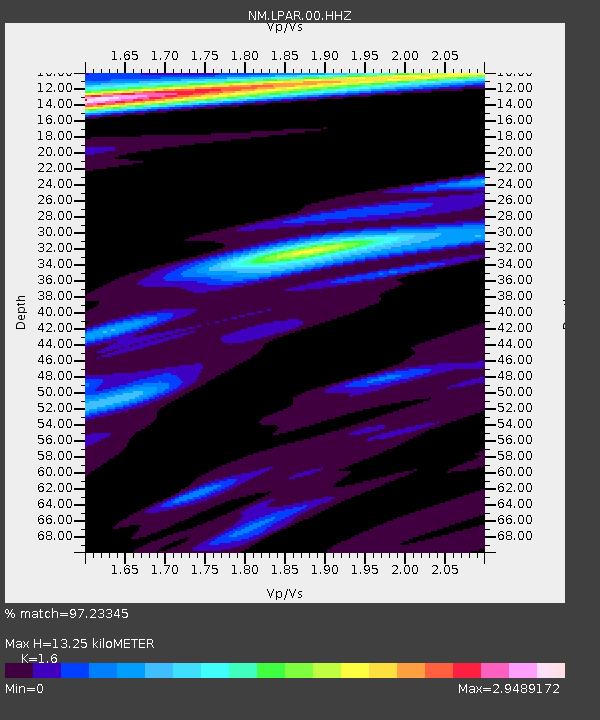
LPAR Lepanto,AR - Earthquake Result Viewer
| Earthquake location: |
East Of Kuril Islands |
| Earthquake latitude/longitude: |
49.0/157.7 |
| Earthquake time(UTC): |
2020/03/25 (085) 02:49:21 GMT |
| Earthquake Depth: |
57 km |
| Earthquake Magnitude: |
7.5 Mww |
| Earthquake Catalog/Contributor: |
NEIC PDE/us |
|
| Network: |
NM Cooperative New Madrid Seismic Network |
| Station: |
LPAR Lepanto,AR |
| Lat/Lon: |
35.60 N/90.30 W |
| Elevation: |
67 m |
|
| Distance: |
76.4 deg |
| Az: |
51.014 deg |
| Baz: |
321.073 deg |
| Ray Param: |
0.050906952 |
| Estimated Moho Depth: |
13.25 km |
| Estimated Crust Vp/Vs: |
1.60 |
| Assumed Crust Vp: |
6.273 km/s |
| Estimated Crust Vs: |
3.921 km/s |
| Estimated Crust Poisson's Ratio: |
0.18 |
|
| Radial Match: |
97.23345 % |
| Radial Bump: |
379 |
| Transverse Match: |
91.30806 % |
| Transverse Bump: |
366 |
| SOD ConfigId: |
20906531 |
| Insert Time: |
2020-04-08 15:09:04.827 +0000 |
| GWidth: |
2.5 |
| Max Bumps: |
400 |
| Tol: |
0.001 |
|

Signal To Noise
| Channel | StoN | STA | LTA |
| NM:LPAR:00:HHZ:20200325T03:00:33.78999Z | 48.24799 | 1.9547875E-5 | 4.051542E-7 |
| NM:LPAR:00:HHN:20200325T03:00:33.78999Z | 8.174366 | 4.691174E-6 | 5.738885E-7 |
| NM:LPAR:00:HHE:20200325T03:00:33.78999Z | 5.0851374 | 4.253081E-6 | 8.3637485E-7 |
| Arrivals |
| Ps | 1.3 SECOND |
| PpPs | 5.3 SECOND |
| PsPs/PpSs | 6.6 SECOND |


