You are here: Home > Network List > NM - Cooperative New Madrid Seismic Network Stations List
> Station MPH Memphis, TN > Earthquake Result Viewer
MPH Memphis, TN - Earthquake Result Viewer
| Earthquake location: |
East Of Kuril Islands |
| Earthquake latitude/longitude: |
49.0/157.7 |
| Earthquake time(UTC): |
2020/03/25 (085) 02:49:21 GMT |
| Earthquake Depth: |
57 km |
| Earthquake Magnitude: |
7.5 Mww |
| Earthquake Catalog/Contributor: |
NEIC PDE/us |
|
| Network: |
NM Cooperative New Madrid Seismic Network |
| Station: |
MPH Memphis, TN |
| Lat/Lon: |
35.12 N/89.93 W |
| Elevation: |
93 m |
|
| Distance: |
77.0 deg |
| Az: |
51.081 deg |
| Baz: |
321.301 deg |
| Ray Param: |
0.050525412 |
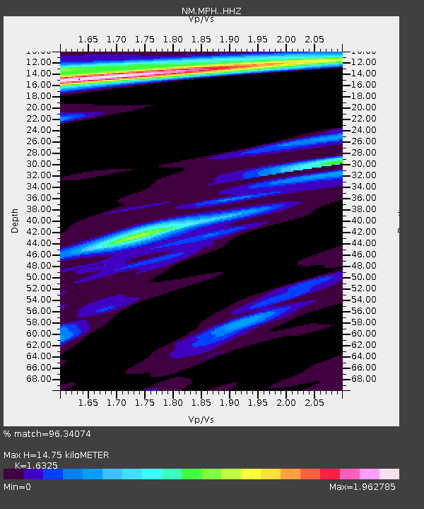
| Estimated Moho Depth: |
14.75 km |
| Estimated Crust Vp/Vs: |
1.63 |
| Assumed Crust Vp: |
6.38 km/s |
| Estimated Crust Vs: |
3.908 km/s |
| Estimated Crust Poisson's Ratio: |
0.20 |
|
| Radial Match: |
96.34074 % |
| Radial Bump: |
243 |
| Transverse Match: |
83.2718 % |
| Transverse Bump: |
310 |
| SOD ConfigId: |
20906531 |
| Insert Time: |
2020-04-08 15:09:07.670 +0000 |
| GWidth: |
2.5 |
| Max Bumps: |
400 |
| Tol: |
0.001 |
|

Signal To Noise
| Channel | StoN | STA | LTA |
| NM:MPH: :HHZ:20200325T03:00:36.940014Z | 51.57947 | 1.6308857E-5 | 3.1618893E-7 |
| NM:MPH: :HHN:20200325T03:00:36.940014Z | 4.5697703 | 3.132663E-6 | 6.855187E-7 |
| NM:MPH: :HHE:20200325T03:00:36.940014Z | 3.106257 | 2.6877965E-6 | 8.652847E-7 |
| Arrivals |
| Ps | 1.5 SECOND |
| PpPs | 5.9 SECOND |
| PsPs/PpSs | 7.4 SECOND |


