You are here: Home > Network List > NN - Western Great Basin/Eastern Sierra Nevada Stations List
> Station GMN Gold Mountain, NV, USA > Earthquake Result Viewer
GMN Gold Mountain, NV, USA - Earthquake Result Viewer
| Earthquake location: |
East Of Kuril Islands |
| Earthquake latitude/longitude: |
49.0/157.7 |
| Earthquake time(UTC): |
2020/03/25 (085) 02:49:21 GMT |
| Earthquake Depth: |
57 km |
| Earthquake Magnitude: |
7.5 Mww |
| Earthquake Catalog/Contributor: |
NEIC PDE/us |
|
| Network: |
NN Western Great Basin/Eastern Sierra Nevada |
| Station: |
GMN Gold Mountain, NV, USA |
| Lat/Lon: |
37.30 N/117.26 W |
| Elevation: |
2168 m |
|
| Distance: |
60.0 deg |
| Az: |
66.485 deg |
| Baz: |
310.757 deg |
| Ray Param: |
0.061660696 |
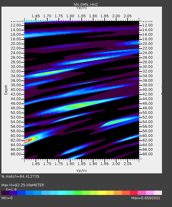
| Estimated Moho Depth: |
62.25 km |
| Estimated Crust Vp/Vs: |
1.60 |
| Assumed Crust Vp: |
6.279 km/s |
| Estimated Crust Vs: |
3.924 km/s |
| Estimated Crust Poisson's Ratio: |
0.18 |
|
| Radial Match: |
94.412735 % |
| Radial Bump: |
400 |
| Transverse Match: |
78.71779 % |
| Transverse Bump: |
400 |
| SOD ConfigId: |
20906531 |
| Insert Time: |
2020-04-08 15:09:32.477 +0000 |
| GWidth: |
2.5 |
| Max Bumps: |
400 |
| Tol: |
0.001 |
|

Signal To Noise
| Channel | StoN | STA | LTA |
| NN:GMN: :HHZ:20200325T02:58:51.64497Z | 45.552963 | 6.0732646E-6 | 1.3332314E-7 |
| NN:GMN: :HHN:20200325T02:58:51.64497Z | 4.175212 | 1.5350129E-6 | 3.6764908E-7 |
| NN:GMN: :HHE:20200325T02:58:51.64497Z | 5.7676773 | 1.5141324E-6 | 2.625203E-7 |
| Arrivals |
| Ps | 6.3 SECOND |
| PpPs | 25 SECOND |
| PsPs/PpSs | 31 SECOND |


