You are here: Home > Network List > NN - Western Great Basin/Eastern Sierra Nevada Stations List
> Station PNT Pine Nut, Nevada w84 > Earthquake Result Viewer
PNT Pine Nut, Nevada w84 - Earthquake Result Viewer
| Earthquake location: |
East Of Kuril Islands |
| Earthquake latitude/longitude: |
49.0/157.7 |
| Earthquake time(UTC): |
2020/03/25 (085) 02:49:21 GMT |
| Earthquake Depth: |
57 km |
| Earthquake Magnitude: |
7.5 Mww |
| Earthquake Catalog/Contributor: |
NEIC PDE/us |
|
| Network: |
NN Western Great Basin/Eastern Sierra Nevada |
| Station: |
PNT Pine Nut, Nevada w84 |
| Lat/Lon: |
39.09 N/119.60 W |
| Elevation: |
2076 m |
|
| Distance: |
57.5 deg |
| Az: |
66.269 deg |
| Baz: |
309.205 deg |
| Ray Param: |
0.06332908 |
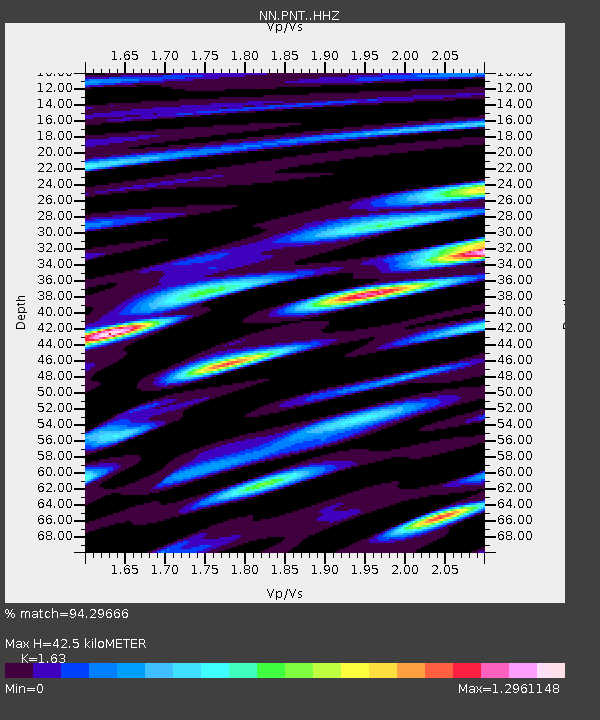
| Estimated Moho Depth: |
42.5 km |
| Estimated Crust Vp/Vs: |
1.63 |
| Assumed Crust Vp: |
6.279 km/s |
| Estimated Crust Vs: |
3.852 km/s |
| Estimated Crust Poisson's Ratio: |
0.20 |
|
| Radial Match: |
94.29666 % |
| Radial Bump: |
400 |
| Transverse Match: |
84.730255 % |
| Transverse Bump: |
400 |
| SOD ConfigId: |
20906531 |
| Insert Time: |
2020-04-08 15:09:45.720 +0000 |
| GWidth: |
2.5 |
| Max Bumps: |
400 |
| Tol: |
0.001 |
|

Signal To Noise
| Channel | StoN | STA | LTA |
| NN:PNT: :HHZ:20200325T02:58:33.925Z | 41.203323 | 1.0077417E-5 | 2.4457776E-7 |
| NN:PNT: :HHN:20200325T02:58:33.925Z | 10.1935625 | 2.9583468E-6 | 2.9021717E-7 |
| NN:PNT: :HHE:20200325T02:58:33.925Z | 12.376368 | 3.399692E-6 | 2.746922E-7 |
| Arrivals |
| Ps | 4.5 SECOND |
| PpPs | 17 SECOND |
| PsPs/PpSs | 21 SECOND |


