You are here: Home > Network List > TS - TERRAscope (Southern California Seismic Network) Stations List
> Station RPV Rancho Palos Verde California, USA > Earthquake Result Viewer
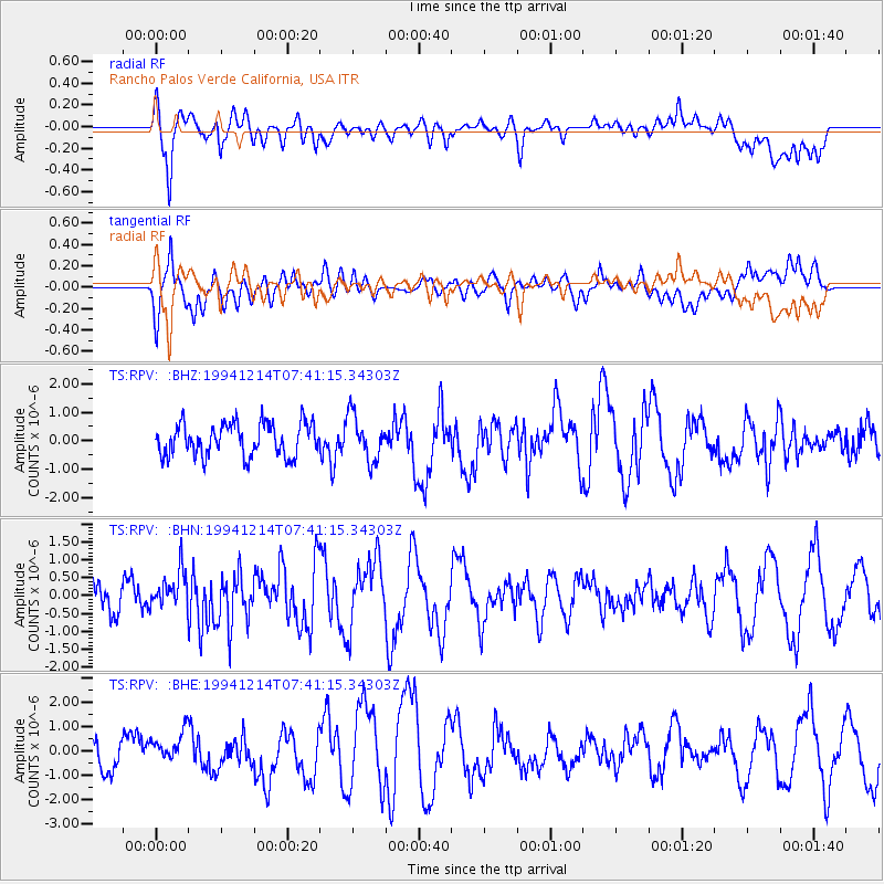
RPV Rancho Palos Verde California, USA - Earthquake Result Viewer
*The percent match for this event was below the threshold and hence no stack was calculated.
| Earthquake location: |
Solomon Islands |
| Earthquake latitude/longitude: |
-9.5/159.3 |
| Earthquake time(UTC): |
1994/12/14 (348) 07:28:55 GMT |
| Earthquake Depth: |
33 km |
| Earthquake Magnitude: |
5.7 MB, 5.9 MS, 5.7 UNKNOWN, 6.1 MW |
| Earthquake Catalog/Contributor: |
WHDF/NEIC |
|
| Network: |
TS TERRAscope (Southern California Seismic Network) |
| Station: |
RPV Rancho Palos Verde California, USA |
| Lat/Lon: |
33.74 N/118.40 W |
| Elevation: |
115 m |
|
| Distance: |
88.9 deg |
| Az: |
55.677 deg |
| Baz: |
257.918 deg |
| Ray Param: |
$rayparam |
*The percent match for this event was below the threshold and hence was not used in the summary stack. |
|
| Radial Match: |
70.50538 % |
| Radial Bump: |
400 |
| Transverse Match: |
62.061897 % |
| Transverse Bump: |
400 |
| SOD ConfigId: |
4480 |
| Insert Time: |
2010-02-26 14:45:33.037 +0000 |
| GWidth: |
2.5 |
| Max Bumps: |
400 |
| Tol: |
0.001 |
|
Signal To Noise
| Channel | StoN | STA | LTA |
| TS:RPV: :BHN:19941214T07:41:15.34303Z | 1.5299786 | 5.210237E-7 | 3.4054312E-7 |
| TS:RPV: :BHE:19941214T07:41:15.34303Z | 1.0215698 | 7.9576665E-7 | 7.7896453E-7 |
| TS:RPV: :BHZ:19941214T07:41:15.34303Z | 1.384508 | 7.9624584E-7 | 5.75111E-7 |
| Arrivals |
| Ps | |
| PpPs | |
| PsPs/PpSs | |


