You are here: Home > Network List > O2 - Oklahoma Consolidated Temporary Seismic Networks Stations List
> Station ARC2 Arcadia, Oklahoma, USA > Earthquake Result Viewer
ARC2 Arcadia, Oklahoma, USA - Earthquake Result Viewer
| Earthquake location: |
East Of Kuril Islands |
| Earthquake latitude/longitude: |
49.0/157.7 |
| Earthquake time(UTC): |
2020/03/25 (085) 02:49:21 GMT |
| Earthquake Depth: |
57 km |
| Earthquake Magnitude: |
7.5 Mww |
| Earthquake Catalog/Contributor: |
NEIC PDE/us |
|
| Network: |
O2 Oklahoma Consolidated Temporary Seismic Networks |
| Station: |
ARC2 Arcadia, Oklahoma, USA |
| Lat/Lon: |
35.74 N/97.27 W |
| Elevation: |
311 m |
|
| Distance: |
72.6 deg |
| Az: |
55.406 deg |
| Baz: |
318.195 deg |
| Ray Param: |
0.053432252 |
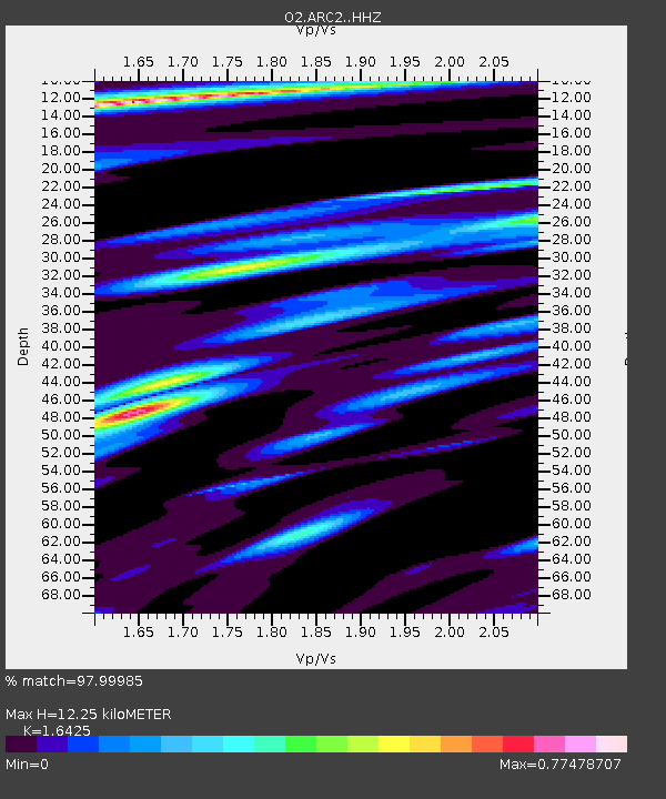
| Estimated Moho Depth: |
12.25 km |
| Estimated Crust Vp/Vs: |
1.64 |
| Assumed Crust Vp: |
6.426 km/s |
| Estimated Crust Vs: |
3.912 km/s |
| Estimated Crust Poisson's Ratio: |
0.21 |
|
| Radial Match: |
97.99985 % |
| Radial Bump: |
287 |
| Transverse Match: |
82.950096 % |
| Transverse Bump: |
400 |
| SOD ConfigId: |
20906531 |
| Insert Time: |
2020-04-08 15:10:37.458 +0000 |
| GWidth: |
2.5 |
| Max Bumps: |
400 |
| Tol: |
0.001 |
|

Signal To Noise
| Channel | StoN | STA | LTA |
| O2:ARC2: :HHZ:20200325T03:00:11.91499Z | 60.763065 | 1.5110189E-5 | 2.486739E-7 |
| O2:ARC2: :HHN:20200325T03:00:11.91499Z | 11.8145075 | 4.6211735E-6 | 3.9114397E-7 |
| O2:ARC2: :HHE:20200325T03:00:11.91499Z | 12.833609 | 4.645243E-6 | 3.619592E-7 |
| Arrivals |
| Ps | 1.3 SECOND |
| PpPs | 4.9 SECOND |
| PsPs/PpSs | 6.1 SECOND |


