You are here: Home > Network List > O2 - Oklahoma Consolidated Temporary Seismic Networks Stations List
> Station CHAN Chandler, Oklahoma, USA > Earthquake Result Viewer
CHAN Chandler, Oklahoma, USA - Earthquake Result Viewer
| Earthquake location: |
East Of Kuril Islands |
| Earthquake latitude/longitude: |
49.0/157.7 |
| Earthquake time(UTC): |
2020/03/25 (085) 02:49:21 GMT |
| Earthquake Depth: |
57 km |
| Earthquake Magnitude: |
7.5 Mww |
| Earthquake Catalog/Contributor: |
NEIC PDE/us |
|
| Network: |
O2 Oklahoma Consolidated Temporary Seismic Networks |
| Station: |
CHAN Chandler, Oklahoma, USA |
| Lat/Lon: |
35.65 N/96.79 W |
| Elevation: |
266 m |
|
| Distance: |
73.0 deg |
| Az: |
55.159 deg |
| Baz: |
318.405 deg |
| Ray Param: |
0.053209644 |
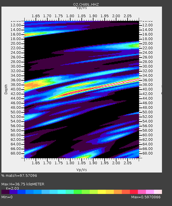
| Estimated Moho Depth: |
36.75 km |
| Estimated Crust Vp/Vs: |
2.03 |
| Assumed Crust Vp: |
6.426 km/s |
| Estimated Crust Vs: |
3.166 km/s |
| Estimated Crust Poisson's Ratio: |
0.34 |
|
| Radial Match: |
97.57096 % |
| Radial Bump: |
296 |
| Transverse Match: |
92.29798 % |
| Transverse Bump: |
400 |
| SOD ConfigId: |
20906531 |
| Insert Time: |
2020-04-08 15:10:40.690 +0000 |
| GWidth: |
2.5 |
| Max Bumps: |
400 |
| Tol: |
0.001 |
|

Signal To Noise
| Channel | StoN | STA | LTA |
| O2:CHAN: :HHZ:20200325T03:00:13.870007Z | 47.641018 | 1.4122981E-5 | 2.9644585E-7 |
| O2:CHAN: :HHN:20200325T03:00:13.870007Z | 8.413115 | 4.411786E-6 | 5.2439395E-7 |
| O2:CHAN: :HHE:20200325T03:00:13.870007Z | 14.420838 | 4.421879E-6 | 3.066312E-7 |
| Arrivals |
| Ps | 6.1 SECOND |
| PpPs | 17 SECOND |
| PsPs/PpSs | 23 SECOND |


