You are here: Home > Network List > OH - Ohio Seismic Network Stations List
> Station KLOH Kiser Lake State Park Ohio > Earthquake Result Viewer
KLOH Kiser Lake State Park Ohio - Earthquake Result Viewer
| Earthquake location: |
East Of Kuril Islands |
| Earthquake latitude/longitude: |
49.0/157.7 |
| Earthquake time(UTC): |
2020/03/25 (085) 02:49:21 GMT |
| Earthquake Depth: |
57 km |
| Earthquake Magnitude: |
7.5 Mww |
| Earthquake Catalog/Contributor: |
NEIC PDE/us |
|
| Network: |
OH Ohio Seismic Network |
| Station: |
KLOH Kiser Lake State Park Ohio |
| Lat/Lon: |
40.20 N/83.97 W |
| Elevation: |
350 m |
|
| Distance: |
75.9 deg |
| Az: |
44.044 deg |
| Baz: |
323.282 deg |
| Ray Param: |
0.051268812 |
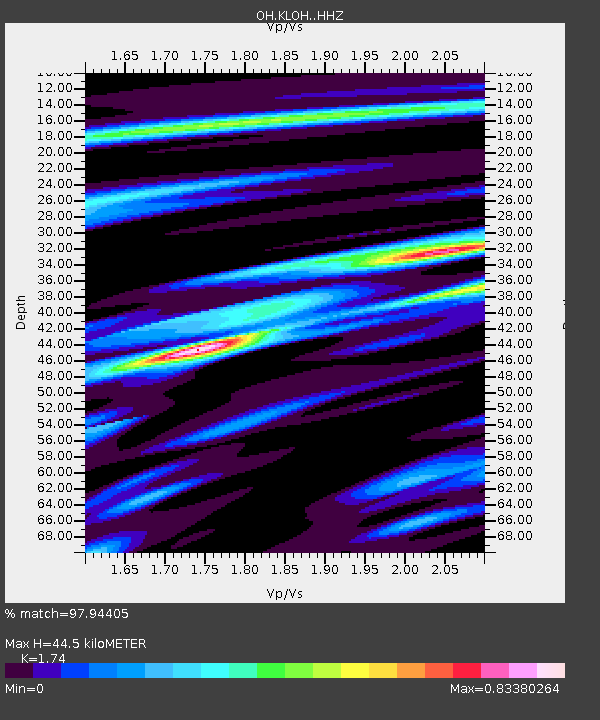
| Estimated Moho Depth: |
44.5 km |
| Estimated Crust Vp/Vs: |
1.74 |
| Assumed Crust Vp: |
6.498 km/s |
| Estimated Crust Vs: |
3.734 km/s |
| Estimated Crust Poisson's Ratio: |
0.25 |
|
| Radial Match: |
97.94405 % |
| Radial Bump: |
300 |
| Transverse Match: |
89.6475 % |
| Transverse Bump: |
400 |
| SOD ConfigId: |
20906531 |
| Insert Time: |
2020-04-08 15:12:16.339 +0000 |
| GWidth: |
2.5 |
| Max Bumps: |
400 |
| Tol: |
0.001 |
|

Signal To Noise
| Channel | StoN | STA | LTA |
| OH:KLOH: :HHZ:20200325T03:00:30.700024Z | 31.452488 | 1.0280433E-5 | 3.2685594E-7 |
| OH:KLOH: :HHN:20200325T03:00:30.700024Z | 8.133992 | 3.5101277E-6 | 4.3153813E-7 |
| OH:KLOH: :HHE:20200325T03:00:30.700024Z | 8.968296 | 3.1444645E-6 | 3.5062004E-7 |
| Arrivals |
| Ps | 5.2 SECOND |
| PpPs | 18 SECOND |
| PsPs/PpSs | 23 SECOND |


