You are here: Home > Network List > OH - Ohio Seismic Network Stations List
> Station SLSO Stonelick State Park Ohio > Earthquake Result Viewer
SLSO Stonelick State Park Ohio - Earthquake Result Viewer
| Earthquake location: |
East Of Kuril Islands |
| Earthquake latitude/longitude: |
49.0/157.7 |
| Earthquake time(UTC): |
2020/03/25 (085) 02:49:21 GMT |
| Earthquake Depth: |
57 km |
| Earthquake Magnitude: |
7.5 Mww |
| Earthquake Catalog/Contributor: |
NEIC PDE/us |
|
| Network: |
OH Ohio Seismic Network |
| Station: |
SLSO Stonelick State Park Ohio |
| Lat/Lon: |
39.22 N/84.06 W |
| Elevation: |
272 m |
|
| Distance: |
76.6 deg |
| Az: |
44.699 deg |
| Baz: |
323.38 deg |
| Ray Param: |
0.050774883 |
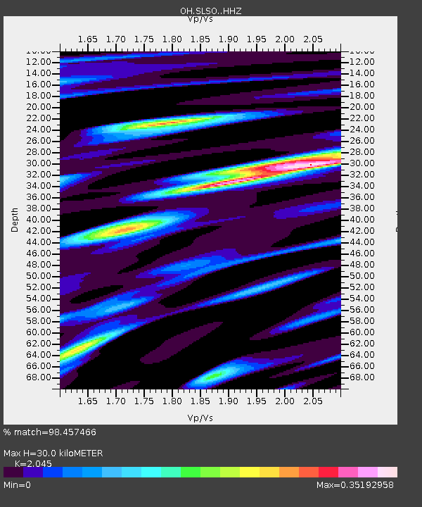
| Estimated Moho Depth: |
30.0 km |
| Estimated Crust Vp/Vs: |
2.05 |
| Assumed Crust Vp: |
6.498 km/s |
| Estimated Crust Vs: |
3.177 km/s |
| Estimated Crust Poisson's Ratio: |
0.34 |
|
| Radial Match: |
98.457466 % |
| Radial Bump: |
285 |
| Transverse Match: |
94.47394 % |
| Transverse Bump: |
400 |
| SOD ConfigId: |
20906531 |
| Insert Time: |
2020-04-08 15:12:25.226 +0000 |
| GWidth: |
2.5 |
| Max Bumps: |
400 |
| Tol: |
0.001 |
|

Signal To Noise
| Channel | StoN | STA | LTA |
| OH:SLSO: :HHZ:20200325T03:00:34.880017Z | 34.569057 | 1.1248844E-5 | 3.254021E-7 |
| OH:SLSO: :HHN:20200325T03:00:34.880017Z | 14.34001 | 3.1912496E-6 | 2.2254167E-7 |
| OH:SLSO: :HHE:20200325T03:00:34.880017Z | 14.468605 | 3.3512658E-6 | 2.3162328E-7 |
| Arrivals |
| Ps | 5.0 SECOND |
| PpPs | 14 SECOND |
| PsPs/PpSs | 19 SECOND |


