You are here: Home > Network List > OX - North-East Italy Seismic Network Stations List
> Station DRE Drenchia > Earthquake Result Viewer
DRE Drenchia - Earthquake Result Viewer
| Earthquake location: |
East Of Kuril Islands |
| Earthquake latitude/longitude: |
49.0/157.7 |
| Earthquake time(UTC): |
2020/03/25 (085) 02:49:21 GMT |
| Earthquake Depth: |
57 km |
| Earthquake Magnitude: |
7.5 Mww |
| Earthquake Catalog/Contributor: |
NEIC PDE/us |
|
| Network: |
OX North-East Italy Seismic Network |
| Station: |
DRE Drenchia |
| Lat/Lon: |
46.17 N/13.65 E |
| Elevation: |
810 m |
|
| Distance: |
80.2 deg |
| Az: |
335.541 deg |
| Baz: |
23.11 deg |
| Ray Param: |
0.048347924 |
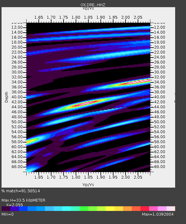
| Estimated Moho Depth: |
33.5 km |
| Estimated Crust Vp/Vs: |
2.06 |
| Assumed Crust Vp: |
6.35 km/s |
| Estimated Crust Vs: |
3.09 km/s |
| Estimated Crust Poisson's Ratio: |
0.34 |
|
| Radial Match: |
91.58514 % |
| Radial Bump: |
400 |
| Transverse Match: |
88.05303 % |
| Transverse Bump: |
400 |
| SOD ConfigId: |
20906531 |
| Insert Time: |
2020-04-08 15:13:09.422 +0000 |
| GWidth: |
2.5 |
| Max Bumps: |
400 |
| Tol: |
0.001 |
|

Signal To Noise
| Channel | StoN | STA | LTA |
| OX:DRE: :HHZ:20200325T03:00:54.52998Z | 24.052235 | 5.3301974E-6 | 2.2160924E-7 |
| OX:DRE: :HHN:20200325T03:00:54.52998Z | 8.721312 | 1.9996546E-6 | 2.2928369E-7 |
| OX:DRE: :HHE:20200325T03:00:54.52998Z | 3.6718724 | 8.4916087E-7 | 2.3126101E-7 |
| Arrivals |
| Ps | 5.7 SECOND |
| PpPs | 16 SECOND |
| PsPs/PpSs | 21 SECOND |


