You are here: Home > Network List > PE - Penn State Network Stations List
> Station PAGS PA Geological Survey, Middletown, PA > Earthquake Result Viewer
PAGS PA Geological Survey, Middletown, PA - Earthquake Result Viewer
| Earthquake location: |
East Of Kuril Islands |
| Earthquake latitude/longitude: |
49.0/157.7 |
| Earthquake time(UTC): |
2020/03/25 (085) 02:49:21 GMT |
| Earthquake Depth: |
57 km |
| Earthquake Magnitude: |
7.5 Mww |
| Earthquake Catalog/Contributor: |
NEIC PDE/us |
|
| Network: |
PE Penn State Network |
| Station: |
PAGS PA Geological Survey, Middletown, PA |
| Lat/Lon: |
40.23 N/76.72 W |
| Elevation: |
120 m |
|
| Distance: |
79.0 deg |
| Az: |
39.363 deg |
| Baz: |
326.927 deg |
| Ray Param: |
0.049147334 |
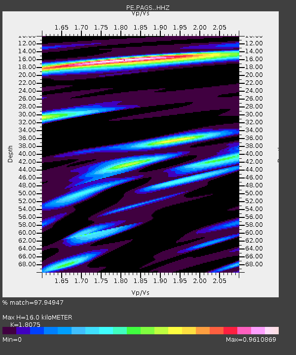
| Estimated Moho Depth: |
16.0 km |
| Estimated Crust Vp/Vs: |
1.81 |
| Assumed Crust Vp: |
6.121 km/s |
| Estimated Crust Vs: |
3.386 km/s |
| Estimated Crust Poisson's Ratio: |
0.28 |
|
| Radial Match: |
97.94947 % |
| Radial Bump: |
362 |
| Transverse Match: |
90.730545 % |
| Transverse Bump: |
400 |
| SOD ConfigId: |
20906531 |
| Insert Time: |
2020-04-08 15:13:28.768 +0000 |
| GWidth: |
2.5 |
| Max Bumps: |
400 |
| Tol: |
0.001 |
|
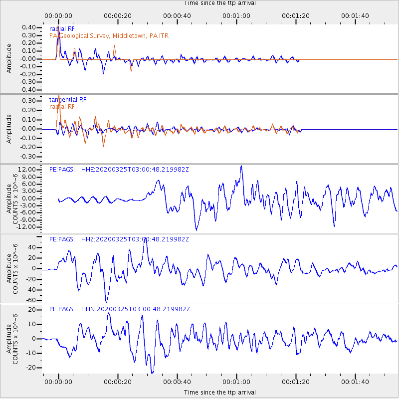
Signal To Noise
| Channel | StoN | STA | LTA |
| PE:PAGS: :HHZ:20200325T03:00:48.219982Z | 18.337069 | 2.0510575E-5 | 1.1185308E-6 |
| PE:PAGS: :HHN:20200325T03:00:48.219982Z | 16.252424 | 6.9426414E-6 | 4.2717573E-7 |
| PE:PAGS: :HHE:20200325T03:00:48.219982Z | 6.5172176 | 4.683875E-6 | 7.186924E-7 |
| Arrivals |
| Ps | 2.2 SECOND |
| PpPs | 7.2 SECOND |
| PsPs/PpSs | 9.3 SECOND |


