You are here: Home > Network List > PE - Penn State Network Stations List
> Station PAMR Moraine State Park, Slippery Rock, PA > Earthquake Result Viewer
PAMR Moraine State Park, Slippery Rock, PA - Earthquake Result Viewer
| Earthquake location: |
East Of Kuril Islands |
| Earthquake latitude/longitude: |
49.0/157.7 |
| Earthquake time(UTC): |
2020/03/25 (085) 02:49:21 GMT |
| Earthquake Depth: |
57 km |
| Earthquake Magnitude: |
7.5 Mww |
| Earthquake Catalog/Contributor: |
NEIC PDE/us |
|
| Network: |
PE Penn State Network |
| Station: |
PAMR Moraine State Park, Slippery Rock, PA |
| Lat/Lon: |
40.94 N/80.10 W |
| Elevation: |
393 m |
|
| Distance: |
77.0 deg |
| Az: |
41.138 deg |
| Baz: |
325.107 deg |
| Ray Param: |
0.050515316 |
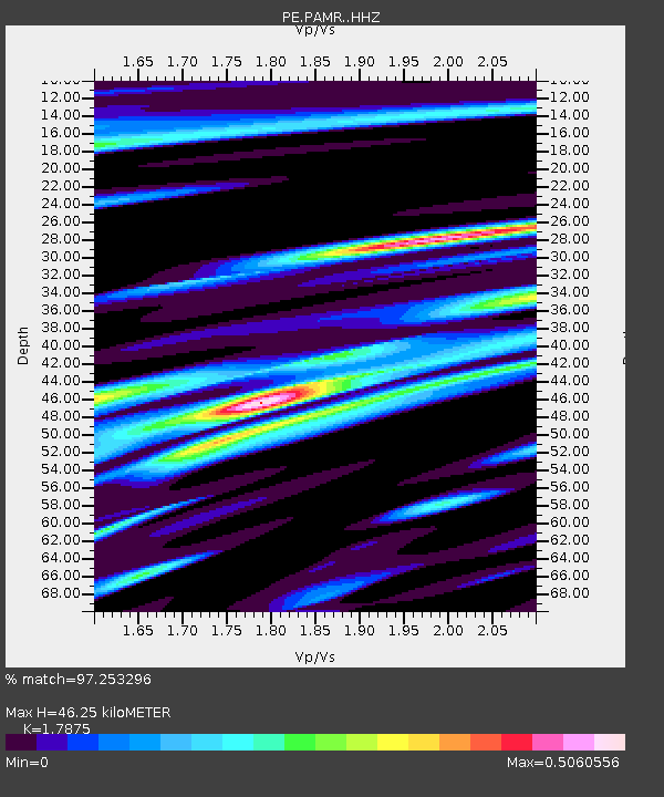
| Estimated Moho Depth: |
46.25 km |
| Estimated Crust Vp/Vs: |
1.79 |
| Assumed Crust Vp: |
6.483 km/s |
| Estimated Crust Vs: |
3.627 km/s |
| Estimated Crust Poisson's Ratio: |
0.27 |
|
| Radial Match: |
97.253296 % |
| Radial Bump: |
330 |
| Transverse Match: |
95.02766 % |
| Transverse Bump: |
400 |
| SOD ConfigId: |
20906531 |
| Insert Time: |
2020-04-08 15:13:37.606 +0000 |
| GWidth: |
2.5 |
| Max Bumps: |
400 |
| Tol: |
0.001 |
|

Signal To Noise
| Channel | StoN | STA | LTA |
| PE:PAMR: :HHZ:20200325T03:00:37.024975Z | 30.361914 | 1.453656E-5 | 4.7877614E-7 |
| PE:PAMR: :HHN:20200325T03:00:37.024975Z | 13.674701 | 4.862572E-6 | 3.555889E-7 |
| PE:PAMR: :HHE:20200325T03:00:37.024975Z | 11.826346 | 3.0798603E-6 | 2.6042366E-7 |
| Arrivals |
| Ps | 5.8 SECOND |
| PpPs | 19 SECOND |
| PsPs/PpSs | 25 SECOND |


