You are here: Home > Network List > PE - Penn State Network Stations List
> Station PSRS Rock Springs Meteorological site, Rock Springs, PA > Earthquake Result Viewer
PSRS Rock Springs Meteorological site, Rock Springs, PA - Earthquake Result Viewer
| Earthquake location: |
East Of Kuril Islands |
| Earthquake latitude/longitude: |
49.0/157.7 |
| Earthquake time(UTC): |
2020/03/25 (085) 02:49:21 GMT |
| Earthquake Depth: |
57 km |
| Earthquake Magnitude: |
7.5 Mww |
| Earthquake Catalog/Contributor: |
NEIC PDE/us |
|
| Network: |
PE Penn State Network |
| Station: |
PSRS Rock Springs Meteorological site, Rock Springs, PA |
| Lat/Lon: |
40.72 N/77.93 W |
| Elevation: |
370 m |
|
| Distance: |
78.1 deg |
| Az: |
39.874 deg |
| Baz: |
326.244 deg |
| Ray Param: |
0.049771916 |
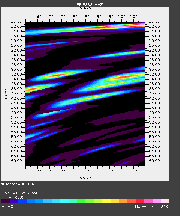
| Estimated Moho Depth: |
11.25 km |
| Estimated Crust Vp/Vs: |
2.07 |
| Assumed Crust Vp: |
6.121 km/s |
| Estimated Crust Vs: |
2.953 km/s |
| Estimated Crust Poisson's Ratio: |
0.35 |
|
| Radial Match: |
98.07497 % |
| Radial Bump: |
342 |
| Transverse Match: |
86.05742 % |
| Transverse Bump: |
400 |
| SOD ConfigId: |
20906531 |
| Insert Time: |
2020-04-08 15:13:48.801 +0000 |
| GWidth: |
2.5 |
| Max Bumps: |
400 |
| Tol: |
0.001 |
|

Signal To Noise
| Channel | StoN | STA | LTA |
| PE:PSRS: :HHZ:20200325T03:00:43.180004Z | 43.254128 | 1.361516E-5 | 3.1477134E-7 |
| PE:PSRS: :HHN:20200325T03:00:43.180004Z | 16.36969 | 4.671063E-6 | 2.8534828E-7 |
| PE:PSRS: :HHE:20200325T03:00:43.180004Z | 12.452998 | 3.2743762E-6 | 2.6293878E-7 |
| Arrivals |
| Ps | 2.0 SECOND |
| PpPs | 5.5 SECOND |
| PsPs/PpSs | 7.5 SECOND |


