You are here: Home > Network List > RV - Regional Alberta Seismic Observatory for Earthquake Studies Network Stations List
> Station DEDWA Deadwood Lookout Tower, AB > Earthquake Result Viewer
DEDWA Deadwood Lookout Tower, AB - Earthquake Result Viewer
| Earthquake location: |
East Of Kuril Islands |
| Earthquake latitude/longitude: |
49.0/157.7 |
| Earthquake time(UTC): |
2020/03/25 (085) 02:49:21 GMT |
| Earthquake Depth: |
57 km |
| Earthquake Magnitude: |
7.5 Mww |
| Earthquake Catalog/Contributor: |
NEIC PDE/us |
|
| Network: |
RV Regional Alberta Seismic Observatory for Earthquake Studies Network |
| Station: |
DEDWA Deadwood Lookout Tower, AB |
| Lat/Lon: |
56.64 N/117.39 W |
| Elevation: |
652 m |
|
| Distance: |
48.7 deg |
| Az: |
47.045 deg |
| Baz: |
299.217 deg |
| Ray Param: |
0.06900036 |
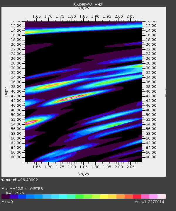
| Estimated Moho Depth: |
42.5 km |
| Estimated Crust Vp/Vs: |
1.80 |
| Assumed Crust Vp: |
6.444 km/s |
| Estimated Crust Vs: |
3.585 km/s |
| Estimated Crust Poisson's Ratio: |
0.28 |
|
| Radial Match: |
96.48892 % |
| Radial Bump: |
349 |
| Transverse Match: |
85.61267 % |
| Transverse Bump: |
400 |
| SOD ConfigId: |
20906531 |
| Insert Time: |
2020-04-08 15:15:04.183 +0000 |
| GWidth: |
2.5 |
| Max Bumps: |
400 |
| Tol: |
0.001 |
|

Signal To Noise
| Channel | StoN | STA | LTA |
| RV:DEDWA: :HHZ:20200325T02:57:29.829998Z | 82.45383 | 1.8148552E-5 | 2.2010565E-7 |
| RV:DEDWA: :HHN:20200325T02:57:29.829998Z | 6.5875125 | 4.8781617E-6 | 7.405165E-7 |
| RV:DEDWA: :HHE:20200325T02:57:29.829998Z | 15.960332 | 9.553139E-6 | 5.985552E-7 |
| Arrivals |
| Ps | 5.6 SECOND |
| PpPs | 17 SECOND |
| PsPs/PpSs | 23 SECOND |


