You are here: Home > Network List > RV - Regional Alberta Seismic Observatory for Earthquake Studies Network Stations List
> Station REDDA Red Deer Airport, AB > Earthquake Result Viewer
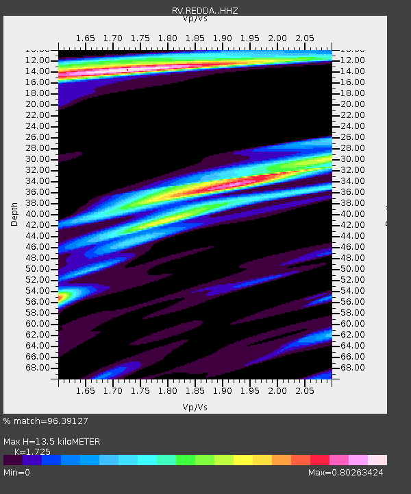
REDDA Red Deer Airport, AB - Earthquake Result Viewer
| Earthquake location: |
East Of Kuril Islands |
| Earthquake latitude/longitude: |
49.0/157.7 |
| Earthquake time(UTC): |
2020/03/25 (085) 02:49:21 GMT |
| Earthquake Depth: |
57 km |
| Earthquake Magnitude: |
7.5 Mww |
| Earthquake Catalog/Contributor: |
NEIC PDE/us |
|
| Network: |
RV Regional Alberta Seismic Observatory for Earthquake Studies Network |
| Station: |
REDDA Red Deer Airport, AB |
| Lat/Lon: |
52.18 N/113.90 W |
| Elevation: |
892 m |
|
| Distance: |
52.8 deg |
| Az: |
50.57 deg |
| Baz: |
304.278 deg |
| Ray Param: |
0.06636365 |
| Estimated Moho Depth: |
13.5 km |
| Estimated Crust Vp/Vs: |
1.73 |
| Assumed Crust Vp: |
6.483 km/s |
| Estimated Crust Vs: |
3.758 km/s |
| Estimated Crust Poisson's Ratio: |
0.25 |
|
| Radial Match: |
96.39127 % |
| Radial Bump: |
250 |
| Transverse Match: |
79.7805 % |
| Transverse Bump: |
400 |
| SOD ConfigId: |
20906531 |
| Insert Time: |
2020-04-08 15:15:16.022 +0000 |
| GWidth: |
2.5 |
| Max Bumps: |
400 |
| Tol: |
0.001 |
|

Signal To Noise
| Channel | StoN | STA | LTA |
| RV:REDDA: :HHZ:20200325T02:58:00.510021Z | 50.912815 | 1.6560807E-5 | 3.2527777E-7 |
| RV:REDDA: :HHN:20200325T02:58:00.510021Z | 7.921605 | 2.4957762E-6 | 3.1505942E-7 |
| RV:REDDA: :HHE:20200325T02:58:00.510021Z | 25.667707 | 8.466105E-6 | 3.2983488E-7 |
| Arrivals |
| Ps | 1.6 SECOND |
| PpPs | 5.4 SECOND |
| PsPs/PpSs | 7.0 SECOND |


