You are here: Home > Network List > S1 - Australian Seismometers in Schools Stations List
> Station AUBSH Beerwah State High School > Earthquake Result Viewer
AUBSH Beerwah State High School - Earthquake Result Viewer
| Earthquake location: |
East Of Kuril Islands |
| Earthquake latitude/longitude: |
49.0/157.7 |
| Earthquake time(UTC): |
2020/03/25 (085) 02:49:21 GMT |
| Earthquake Depth: |
57 km |
| Earthquake Magnitude: |
7.5 Mww |
| Earthquake Catalog/Contributor: |
NEIC PDE/us |
|
| Network: |
S1 Australian Seismometers in Schools |
| Station: |
AUBSH Beerwah State High School |
| Lat/Lon: |
26.86 S/152.95 E |
| Elevation: |
26 m |
|
| Distance: |
75.6 deg |
| Az: |
184.369 deg |
| Baz: |
3.22 deg |
| Ray Param: |
0.05143787 |
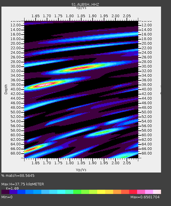
| Estimated Moho Depth: |
37.75 km |
| Estimated Crust Vp/Vs: |
1.69 |
| Assumed Crust Vp: |
6.472 km/s |
| Estimated Crust Vs: |
3.83 km/s |
| Estimated Crust Poisson's Ratio: |
0.23 |
|
| Radial Match: |
88.5645 % |
| Radial Bump: |
400 |
| Transverse Match: |
76.32889 % |
| Transverse Bump: |
400 |
| SOD ConfigId: |
20906531 |
| Insert Time: |
2020-04-08 15:15:27.213 +0000 |
| GWidth: |
2.5 |
| Max Bumps: |
400 |
| Tol: |
0.001 |
|

Signal To Noise
| Channel | StoN | STA | LTA |
| S1:AUBSH: :HHZ:20200325T03:00:29.310009Z | 10.764489 | 5.422662E-6 | 5.037547E-7 |
| S1:AUBSH: :HHN:20200325T03:00:29.310009Z | 1.426027 | 1.301888E-6 | 9.129476E-7 |
| S1:AUBSH: :HHE:20200325T03:00:29.310009Z | 0.6192843 | 6.9943013E-7 | 1.1294169E-6 |
| Arrivals |
| Ps | 4.2 SECOND |
| PpPs | 15 SECOND |
| PsPs/PpSs | 19 SECOND |


