You are here: Home > Network List > S1 - Australian Seismometers in Schools Stations List
> Station AUPKL Parklands High School > Earthquake Result Viewer
AUPKL Parklands High School - Earthquake Result Viewer
| Earthquake location: |
East Of Kuril Islands |
| Earthquake latitude/longitude: |
49.0/157.7 |
| Earthquake time(UTC): |
2020/03/25 (085) 02:49:21 GMT |
| Earthquake Depth: |
57 km |
| Earthquake Magnitude: |
7.5 Mww |
| Earthquake Catalog/Contributor: |
NEIC PDE/us |
|
| Network: |
S1 Australian Seismometers in Schools |
| Station: |
AUPKL Parklands High School |
| Lat/Lon: |
41.08 S/145.90 E |
| Elevation: |
171 m |
|
| Distance: |
90.3 deg |
| Az: |
188.887 deg |
| Baz: |
7.737 deg |
| Ray Param: |
0.041705076 |
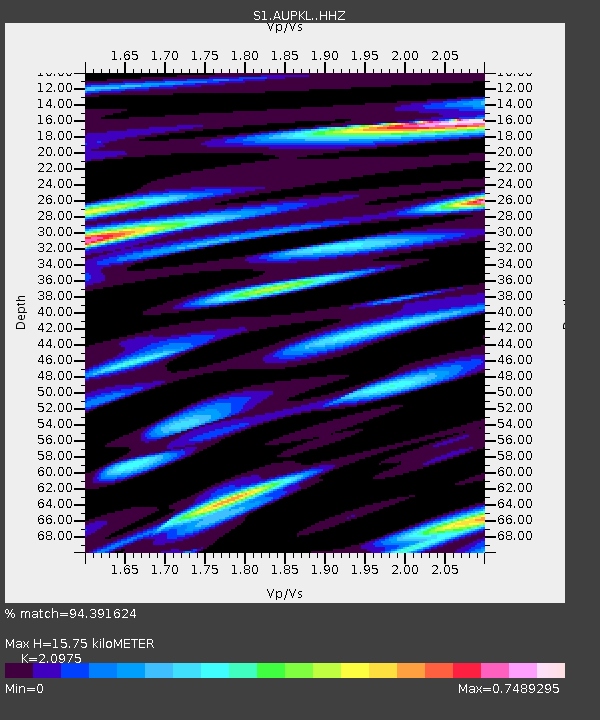
| Estimated Moho Depth: |
15.75 km |
| Estimated Crust Vp/Vs: |
2.10 |
| Assumed Crust Vp: |
6.477 km/s |
| Estimated Crust Vs: |
3.088 km/s |
| Estimated Crust Poisson's Ratio: |
0.35 |
|
| Radial Match: |
94.391624 % |
| Radial Bump: |
385 |
| Transverse Match: |
91.25035 % |
| Transverse Bump: |
400 |
| SOD ConfigId: |
20906531 |
| Insert Time: |
2020-04-08 15:15:54.959 +0000 |
| GWidth: |
2.5 |
| Max Bumps: |
400 |
| Tol: |
0.001 |
|

Signal To Noise
| Channel | StoN | STA | LTA |
| S1:AUPKL: :HHZ:20200325T03:01:44.760021Z | 6.2047067 | 4.200496E-6 | 6.769854E-7 |
| S1:AUPKL: :HHN:20200325T03:01:44.760021Z | 2.914184 | 1.7613339E-6 | 6.044004E-7 |
| S1:AUPKL: :HHE:20200325T03:01:44.760021Z | 2.9731572 | 1.4615756E-6 | 4.915904E-7 |
| Arrivals |
| Ps | 2.7 SECOND |
| PpPs | 7.4 SECOND |
| PsPs/PpSs | 10 SECOND |


