You are here: Home > Network List > SC - New Mexico Tech Seismic Network Stations List
> Station PDB New Mexico Tech Seismic Network > Earthquake Result Viewer
PDB New Mexico Tech Seismic Network - Earthquake Result Viewer
| Earthquake location: |
East Of Kuril Islands |
| Earthquake latitude/longitude: |
49.0/157.7 |
| Earthquake time(UTC): |
2020/03/25 (085) 02:49:21 GMT |
| Earthquake Depth: |
57 km |
| Earthquake Magnitude: |
7.5 Mww |
| Earthquake Catalog/Contributor: |
NEIC PDE/us |
|
| Network: |
SC New Mexico Tech Seismic Network |
| Station: |
PDB New Mexico Tech Seismic Network |
| Lat/Lon: |
32.07 N/103.60 W |
| Elevation: |
1025 m |
|
| Distance: |
71.8 deg |
| Az: |
62.073 deg |
| Baz: |
316.72 deg |
| Ray Param: |
0.054000698 |
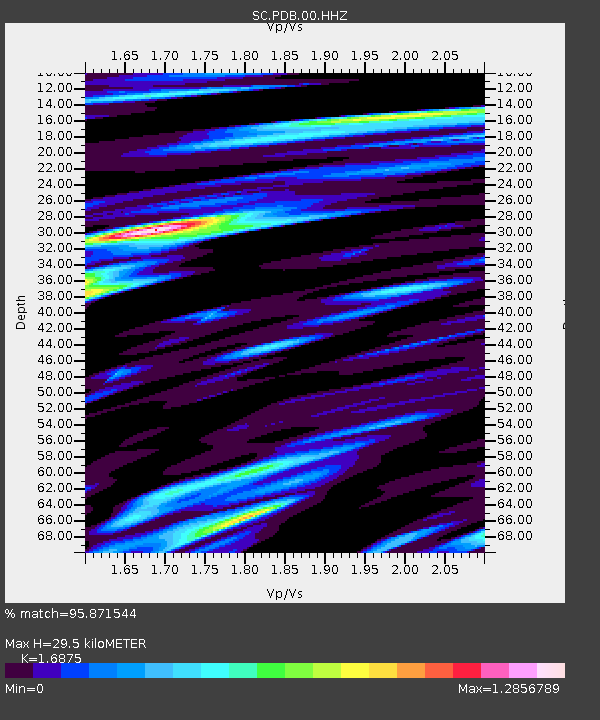
| Estimated Moho Depth: |
29.5 km |
| Estimated Crust Vp/Vs: |
1.69 |
| Assumed Crust Vp: |
6.129 km/s |
| Estimated Crust Vs: |
3.632 km/s |
| Estimated Crust Poisson's Ratio: |
0.23 |
|
| Radial Match: |
95.871544 % |
| Radial Bump: |
381 |
| Transverse Match: |
95.59268 % |
| Transverse Bump: |
400 |
| SOD ConfigId: |
20906531 |
| Insert Time: |
2020-04-08 15:16:04.667 +0000 |
| GWidth: |
2.5 |
| Max Bumps: |
400 |
| Tol: |
0.001 |
|

Signal To Noise
| Channel | StoN | STA | LTA |
| SC:PDB:00:HHZ:20200325T03:00:06.774975Z | 44.59448 | 6.480958E-7 | 1.4533095E-8 |
| SC:PDB:00:HHN:20200325T03:00:06.774975Z | 19.56727 | 2.1964323E-7 | 1.1225032E-8 |
| SC:PDB:00:HHE:20200325T03:00:06.774975Z | 52.059025 | 7.164474E-7 | 1.3762214E-8 |
| Arrivals |
| Ps | 3.4 SECOND |
| PpPs | 13 SECOND |
| PsPs/PpSs | 16 SECOND |


