You are here: Home > Network List > SV - Servicio Nacional de Estudios Territoriales (SNET), El Salvador Stations List
> Station MTO3 Montecristo > Earthquake Result Viewer
MTO3 Montecristo - Earthquake Result Viewer
| Earthquake location: |
East Of Kuril Islands |
| Earthquake latitude/longitude: |
49.0/157.7 |
| Earthquake time(UTC): |
2020/03/25 (085) 02:49:21 GMT |
| Earthquake Depth: |
57 km |
| Earthquake Magnitude: |
7.5 Mww |
| Earthquake Catalog/Contributor: |
NEIC PDE/us |
|
| Network: |
SV Servicio Nacional de Estudios Territoriales (SNET), El Salvador |
| Station: |
MTO3 Montecristo |
| Lat/Lon: |
14.40 N/89.36 W |
| Elevation: |
1830 m |
|
| Distance: |
93.6 deg |
| Az: |
63.391 deg |
| Baz: |
322.568 deg |
| Ray Param: |
0.04120368 |
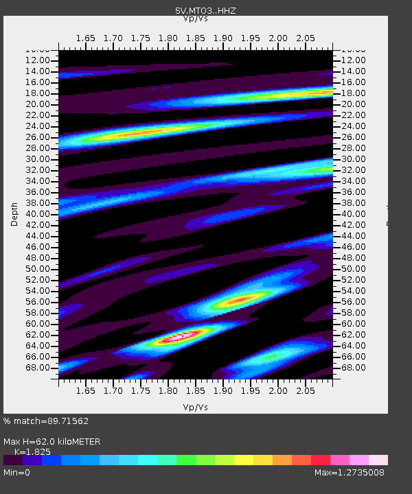
| Estimated Moho Depth: |
62.0 km |
| Estimated Crust Vp/Vs: |
1.83 |
| Assumed Crust Vp: |
6.597 km/s |
| Estimated Crust Vs: |
3.615 km/s |
| Estimated Crust Poisson's Ratio: |
0.29 |
|
| Radial Match: |
89.71562 % |
| Radial Bump: |
400 |
| Transverse Match: |
84.13307 % |
| Transverse Bump: |
400 |
| SOD ConfigId: |
20906531 |
| Insert Time: |
2020-04-08 15:16:22.859 +0000 |
| GWidth: |
2.5 |
| Max Bumps: |
400 |
| Tol: |
0.001 |
|

Signal To Noise
| Channel | StoN | STA | LTA |
| SV:MTO3: :HHZ:20200325T03:02:00.050Z | 33.94761 | 4.6898026E-6 | 1.3814825E-7 |
| SV:MTO3: :HHN:20200325T03:02:00.050Z | 13.630799 | 1.5284378E-6 | 1.1213119E-7 |
| SV:MTO3: :HHE:20200325T03:02:00.050Z | 5.531849 | 5.7960716E-7 | 1.0477639E-7 |
| Arrivals |
| Ps | 7.9 SECOND |
| PpPs | 26 SECOND |
| PsPs/PpSs | 34 SECOND |


