You are here: Home > Network List > TA - USArray Transportable Network (new EarthScope stations) Stations List
> Station E29M Blow River, YT, CAN > Earthquake Result Viewer
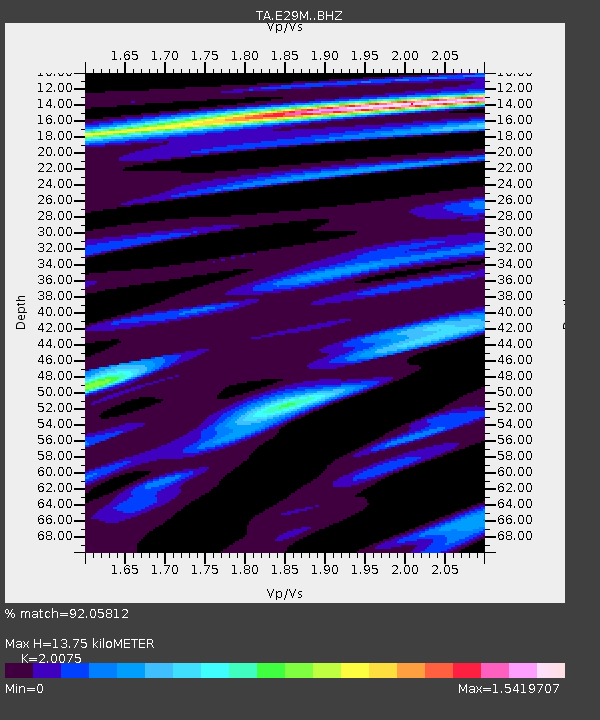
E29M Blow River, YT, CAN - Earthquake Result Viewer
| Earthquake location: |
East Of Kuril Islands |
| Earthquake latitude/longitude: |
49.0/157.7 |
| Earthquake time(UTC): |
2020/03/25 (085) 02:49:21 GMT |
| Earthquake Depth: |
57 km |
| Earthquake Magnitude: |
7.5 Mww |
| Earthquake Catalog/Contributor: |
NEIC PDE/us |
|
| Network: |
TA USArray Transportable Network (new EarthScope stations) |
| Station: |
E29M Blow River, YT, CAN |
| Lat/Lon: |
68.39 N/137.90 W |
| Elevation: |
324 m |
|
| Distance: |
36.5 deg |
| Az: |
34.207 deg |
| Baz: |
271.391 deg |
| Ray Param: |
0.07654512 |
| Estimated Moho Depth: |
13.75 km |
| Estimated Crust Vp/Vs: |
2.01 |
| Assumed Crust Vp: |
5.981 km/s |
| Estimated Crust Vs: |
2.979 km/s |
| Estimated Crust Poisson's Ratio: |
0.33 |
|
| Radial Match: |
92.05812 % |
| Radial Bump: |
400 |
| Transverse Match: |
75.82921 % |
| Transverse Bump: |
400 |
| SOD ConfigId: |
20906531 |
| Insert Time: |
2020-04-08 15:17:00.716 +0000 |
| GWidth: |
2.5 |
| Max Bumps: |
400 |
| Tol: |
0.001 |
|

Signal To Noise
| Channel | StoN | STA | LTA |
| TA:E29M: :BHZ:20200325T02:55:50.474987Z | 96.2288 | 1.7919374E-5 | 1.8621634E-7 |
| TA:E29M: :BHN:20200325T02:55:50.474987Z | 8.541034 | 9.030191E-7 | 1.0572714E-7 |
| TA:E29M: :BHE:20200325T02:55:50.474987Z | 39.797234 | 1.0134065E-5 | 2.5464246E-7 |
| Arrivals |
| Ps | 2.4 SECOND |
| PpPs | 6.5 SECOND |
| PsPs/PpSs | 9.0 SECOND |


