You are here: Home > Network List > US - United States National Seismic Network Stations List
> Station AMTX Amarillo, Texas, USA > Earthquake Result Viewer
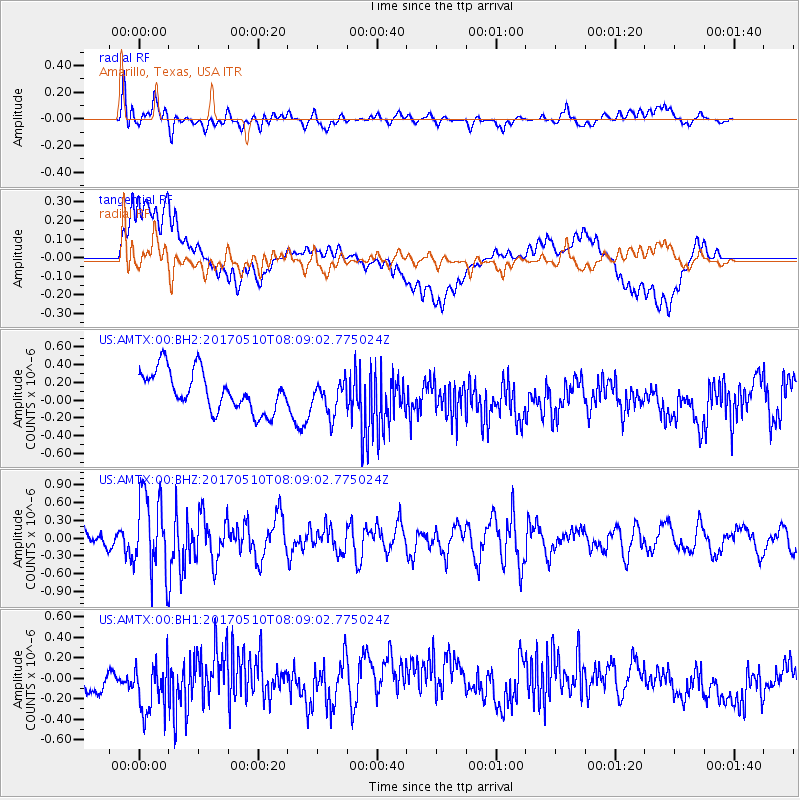
AMTX Amarillo, Texas, USA - Earthquake Result Viewer
*The percent match for this event was below the threshold and hence no stack was calculated.
| Earthquake location: |
Andreanof Islands, Aleutian Is. |
| Earthquake latitude/longitude: |
51.4/-178.5 |
| Earthquake time(UTC): |
2017/05/10 (130) 07:59:55 GMT |
| Earthquake Depth: |
1.0 km |
| Earthquake Magnitude: |
6.0 Mi |
| Earthquake Catalog/Contributor: |
NEIC PDE/at |
|
| Network: |
US United States National Seismic Network |
| Station: |
AMTX Amarillo, Texas, USA |
| Lat/Lon: |
34.53 N/101.41 W |
| Elevation: |
1010 m |
|
| Distance: |
56.2 deg |
| Az: |
75.443 deg |
| Baz: |
312.795 deg |
| Ray Param: |
$rayparam |
*The percent match for this event was below the threshold and hence was not used in the summary stack. |
|
| Radial Match: |
50.18884 % |
| Radial Bump: |
400 |
| Transverse Match: |
47.93362 % |
| Transverse Bump: |
400 |
| SOD ConfigId: |
2028011 |
| Insert Time: |
2017-05-24 08:04:50.194 +0000 |
| GWidth: |
2.5 |
| Max Bumps: |
400 |
| Tol: |
0.001 |
|
Signal To Noise
| Channel | StoN | STA | LTA |
| US:AMTX:00:BHZ:20170510T08:09:02.775024Z | 5.099619 | 6.7722317E-7 | 1.3279879E-7 |
| US:AMTX:00:BH1:20170510T08:09:02.775024Z | 1.3514647 | 2.7547728E-7 | 2.038361E-7 |
| US:AMTX:00:BH2:20170510T08:09:02.775024Z | 1.2261747 | 2.9230443E-7 | 2.3838727E-7 |
| Arrivals |
| Ps | |
| PpPs | |
| PsPs/PpSs | |


