You are here: Home > Network List > TA - USArray Transportable Network (new EarthScope stations) Stations List
> Station J30M Hart River, Yukon, CAN > Earthquake Result Viewer
J30M Hart River, Yukon, CAN - Earthquake Result Viewer
| Earthquake location: |
East Of Kuril Islands |
| Earthquake latitude/longitude: |
49.0/157.7 |
| Earthquake time(UTC): |
2020/03/25 (085) 02:49:21 GMT |
| Earthquake Depth: |
57 km |
| Earthquake Magnitude: |
7.5 Mww |
| Earthquake Catalog/Contributor: |
NEIC PDE/us |
|
| Network: |
TA USArray Transportable Network (new EarthScope stations) |
| Station: |
J30M Hart River, Yukon, CAN |
| Lat/Lon: |
64.58 N/136.33 W |
| Elevation: |
1419 m |
|
| Distance: |
37.4 deg |
| Az: |
40.48 deg |
| Baz: |
277.842 deg |
| Ray Param: |
0.076007664 |
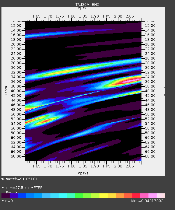
| Estimated Moho Depth: |
47.5 km |
| Estimated Crust Vp/Vs: |
1.63 |
| Assumed Crust Vp: |
6.566 km/s |
| Estimated Crust Vs: |
4.028 km/s |
| Estimated Crust Poisson's Ratio: |
0.20 |
|
| Radial Match: |
91.05101 % |
| Radial Bump: |
380 |
| Transverse Match: |
72.58498 % |
| Transverse Bump: |
400 |
| SOD ConfigId: |
20906531 |
| Insert Time: |
2020-04-08 15:17:33.529 +0000 |
| GWidth: |
2.5 |
| Max Bumps: |
400 |
| Tol: |
0.001 |
|

Signal To Noise
| Channel | StoN | STA | LTA |
| TA:J30M: :BHZ:20200325T02:55:58.400006Z | 40.485596 | 1.4095125E-5 | 3.4815162E-7 |
| TA:J30M: :BHN:20200325T02:55:58.400006Z | 19.09758 | 2.1631442E-6 | 1.1326797E-7 |
| TA:J30M: :BHE:20200325T02:55:58.400006Z | 31.298641 | 9.428334E-6 | 3.012378E-7 |
| Arrivals |
| Ps | 5.0 SECOND |
| PpPs | 17 SECOND |
| PsPs/PpSs | 22 SECOND |


