You are here: Home > Network List > TX - Texas Seismological Network Stations List
> Station FW15 Z > Earthquake Result Viewer
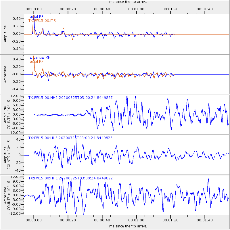
FW15 Z - Earthquake Result Viewer

| Earthquake location: |
East Of Kuril Islands |
| Earthquake latitude/longitude: |
49.0/157.7 |
| Earthquake time(UTC): |
2020/03/25 (085) 02:49:21 GMT |
| Earthquake Depth: |
57 km |
| Earthquake Magnitude: |
7.5 Mww |
| Earthquake Catalog/Contributor: |
NEIC PDE/us |
|
| Network: |
TX Texas Seismological Network |
| Station: |
FW15 Z |
| Lat/Lon: |
32.70 N/97.37 W |
| Elevation: |
192 m |
|
| Distance: |
74.8 deg |
| Az: |
57.562 deg |
| Baz: |
318.745 deg |
| Ray Param: |
0.051952112 |
| Estimated Moho Depth: |
41.5 km |
| Estimated Crust Vp/Vs: |
1.84 |
| Assumed Crust Vp: |
6.38 km/s |
| Estimated Crust Vs: |
3.468 km/s |
| Estimated Crust Poisson's Ratio: |
0.29 |
|
| Radial Match: |
91.83792 % |
| Radial Bump: |
265 |
| Transverse Match: |
82.19897 % |
| Transverse Bump: |
375 |
| SOD ConfigId: |
20906531 |
| Insert Time: |
2020-04-08 15:19:19.550 +0000 |
| GWidth: |
2.5 |
| Max Bumps: |
400 |
| Tol: |
0.001 |
|
Signal To Noise
| Channel | StoN | STA | LTA |
| TX:FW15:00:HHZ:20200325T03:00:24.844982Z | 34.051434 | 7.4039444E-6 | 2.1743415E-7 |
| TX:FW15:00:HH1:20200325T03:00:24.844982Z | 10.09279 | 2.3681175E-6 | 2.346346E-7 |
| TX:FW15:00:HH2:20200325T03:00:24.844982Z | 10.114661 | 2.1255535E-6 | 2.1014579E-7 |
| Arrivals |
| Ps | 5.6 SECOND |
| PpPs | 18 SECOND |
| PsPs/PpSs | 24 SECOND |


