You are here: Home > Network List > TX - Texas Seismological Network Stations List
> Station MB02 Rankin > Earthquake Result Viewer
MB02 Rankin - Earthquake Result Viewer
| Earthquake location: |
East Of Kuril Islands |
| Earthquake latitude/longitude: |
49.0/157.7 |
| Earthquake time(UTC): |
2020/03/25 (085) 02:49:21 GMT |
| Earthquake Depth: |
57 km |
| Earthquake Magnitude: |
7.5 Mww |
| Earthquake Catalog/Contributor: |
NEIC PDE/us |
|
| Network: |
TX Texas Seismological Network |
| Station: |
MB02 Rankin |
| Lat/Lon: |
31.20 N/102.04 W |
| Elevation: |
768 m |
|
| Distance: |
73.3 deg |
| Az: |
61.675 deg |
| Baz: |
317.414 deg |
| Ray Param: |
0.052976884 |
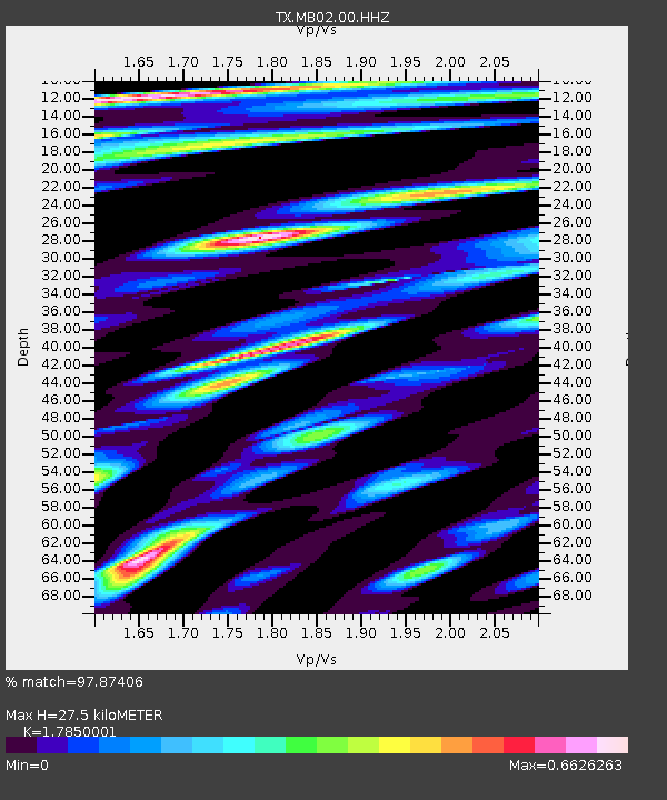
| Estimated Moho Depth: |
27.5 km |
| Estimated Crust Vp/Vs: |
1.79 |
| Assumed Crust Vp: |
6.121 km/s |
| Estimated Crust Vs: |
3.429 km/s |
| Estimated Crust Poisson's Ratio: |
0.27 |
|
| Radial Match: |
97.87406 % |
| Radial Bump: |
385 |
| Transverse Match: |
96.14192 % |
| Transverse Bump: |
400 |
| SOD ConfigId: |
20906531 |
| Insert Time: |
2020-04-08 15:19:28.474 +0000 |
| GWidth: |
2.5 |
| Max Bumps: |
400 |
| Tol: |
0.001 |
|

Signal To Noise
| Channel | StoN | STA | LTA |
| TX:MB02:00:HHZ:20200325T03:00:15.930004Z | 66.599594 | 7.326512E-6 | 1.1000835E-7 |
| TX:MB02:00:HH1:20200325T03:00:15.930004Z | 18.859596 | 1.5567495E-6 | 8.2544155E-8 |
| TX:MB02:00:HH2:20200325T03:00:15.930004Z | 37.569458 | 2.9249065E-6 | 7.785331E-8 |
| Arrivals |
| Ps | 3.6 SECOND |
| PpPs | 12 SECOND |
| PsPs/PpSs | 16 SECOND |


