You are here: Home > Network List > TX - Texas Seismological Network Stations List
> Station PB27 North of Pyote > Earthquake Result Viewer
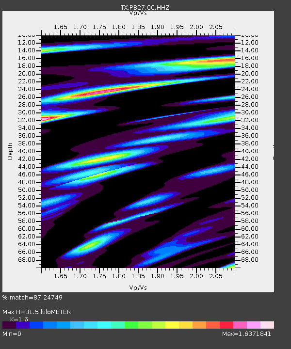
PB27 North of Pyote - Earthquake Result Viewer
| Earthquake location: |
East Of Kuril Islands |
| Earthquake latitude/longitude: |
49.0/157.7 |
| Earthquake time(UTC): |
2020/03/25 (085) 02:49:21 GMT |
| Earthquake Depth: |
57 km |
| Earthquake Magnitude: |
7.5 Mww |
| Earthquake Catalog/Contributor: |
NEIC PDE/us |
|
| Network: |
TX Texas Seismological Network |
| Station: |
PB27 North of Pyote |
| Lat/Lon: |
31.58 N/103.13 W |
| Elevation: |
812 m |
|
| Distance: |
72.4 deg |
| Az: |
62.125 deg |
| Baz: |
316.98 deg |
| Ray Param: |
0.053582303 |
| Estimated Moho Depth: |
31.5 km |
| Estimated Crust Vp/Vs: |
1.60 |
| Assumed Crust Vp: |
6.121 km/s |
| Estimated Crust Vs: |
3.825 km/s |
| Estimated Crust Poisson's Ratio: |
0.18 |
|
| Radial Match: |
87.24749 % |
| Radial Bump: |
400 |
| Transverse Match: |
83.76781 % |
| Transverse Bump: |
400 |
| SOD ConfigId: |
20906531 |
| Insert Time: |
2020-04-08 15:20:02.079 +0000 |
| GWidth: |
2.5 |
| Max Bumps: |
400 |
| Tol: |
0.001 |
|

Signal To Noise
| Channel | StoN | STA | LTA |
| TX:PB27:00:HHZ:20200325T03:00:10.53999Z | 44.94642 | 1.1635309E-5 | 2.5887067E-7 |
| TX:PB27:00:HHN:20200325T03:00:10.53999Z | 15.736163 | 3.4996297E-6 | 2.2239409E-7 |
| TX:PB27:00:HHE:20200325T03:00:10.53999Z | 19.694908 | 3.703447E-6 | 1.8804084E-7 |
| Arrivals |
| Ps | 3.2 SECOND |
| PpPs | 13 SECOND |
| PsPs/PpSs | 16 SECOND |


