You are here: Home > Network List > TX - Texas Seismological Network Stations List
> Station SGCY Sterling City > Earthquake Result Viewer
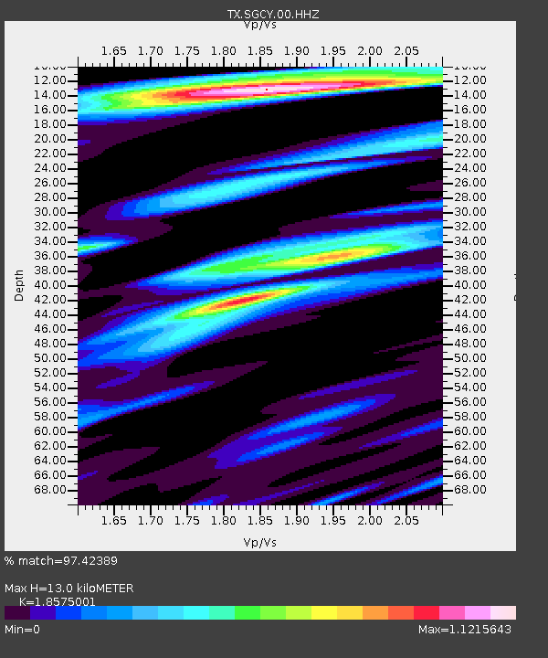
SGCY Sterling City - Earthquake Result Viewer
| Earthquake location: |
East Of Kuril Islands |
| Earthquake latitude/longitude: |
49.0/157.7 |
| Earthquake time(UTC): |
2020/03/25 (085) 02:49:21 GMT |
| Earthquake Depth: |
57 km |
| Earthquake Magnitude: |
7.5 Mww |
| Earthquake Catalog/Contributor: |
NEIC PDE/us |
|
| Network: |
TX Texas Seismological Network |
| Station: |
SGCY Sterling City |
| Lat/Lon: |
31.91 N/101.13 W |
| Elevation: |
776 m |
|
| Distance: |
73.3 deg |
| Az: |
60.573 deg |
| Baz: |
317.572 deg |
| Ray Param: |
0.052977312 |
| Estimated Moho Depth: |
13.0 km |
| Estimated Crust Vp/Vs: |
1.86 |
| Assumed Crust Vp: |
6.38 km/s |
| Estimated Crust Vs: |
3.435 km/s |
| Estimated Crust Poisson's Ratio: |
0.30 |
|
| Radial Match: |
97.42389 % |
| Radial Bump: |
392 |
| Transverse Match: |
89.062035 % |
| Transverse Bump: |
400 |
| SOD ConfigId: |
20906531 |
| Insert Time: |
2020-04-08 15:20:16.938 +0000 |
| GWidth: |
2.5 |
| Max Bumps: |
400 |
| Tol: |
0.001 |
|

Signal To Noise
| Channel | StoN | STA | LTA |
| TX:SGCY:00:HHZ:20200325T03:00:15.919995Z | 76.72536 | 1.5697242E-5 | 2.0459002E-7 |
| TX:SGCY:00:HH1:20200325T03:00:15.919995Z | 34.881638 | 5.629243E-6 | 1.6138128E-7 |
| TX:SGCY:00:HH2:20200325T03:00:15.919995Z | 31.116013 | 3.4388195E-6 | 1.1051607E-7 |
| Arrivals |
| Ps | 1.8 SECOND |
| PpPs | 5.6 SECOND |
| PsPs/PpSs | 7.4 SECOND |


