You are here: Home > Network List > TX - Texas Seismological Network Stations List
> Station SN10 Rotan > Earthquake Result Viewer
SN10 Rotan - Earthquake Result Viewer
| Earthquake location: |
East Of Kuril Islands |
| Earthquake latitude/longitude: |
49.0/157.7 |
| Earthquake time(UTC): |
2020/03/25 (085) 02:49:21 GMT |
| Earthquake Depth: |
57 km |
| Earthquake Magnitude: |
7.5 Mww |
| Earthquake Catalog/Contributor: |
NEIC PDE/us |
|
| Network: |
TX Texas Seismological Network |
| Station: |
SN10 Rotan |
| Lat/Lon: |
33.05 N/100.72 W |
| Elevation: |
658 m |
|
| Distance: |
72.7 deg |
| Az: |
59.511 deg |
| Baz: |
317.477 deg |
| Ray Param: |
0.053382073 |
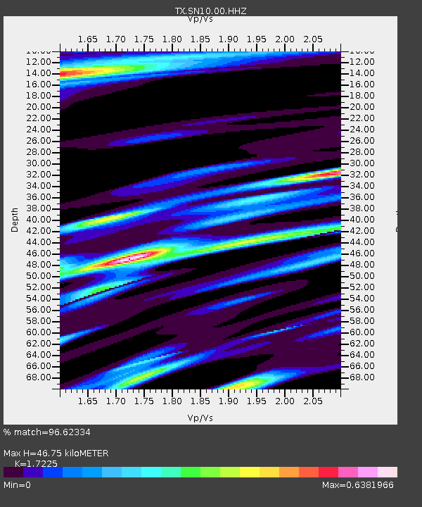
| Estimated Moho Depth: |
46.75 km |
| Estimated Crust Vp/Vs: |
1.72 |
| Assumed Crust Vp: |
6.426 km/s |
| Estimated Crust Vs: |
3.731 km/s |
| Estimated Crust Poisson's Ratio: |
0.25 |
|
| Radial Match: |
96.62334 % |
| Radial Bump: |
329 |
| Transverse Match: |
91.893555 % |
| Transverse Bump: |
400 |
| SOD ConfigId: |
20906531 |
| Insert Time: |
2020-04-08 15:20:25.186 +0000 |
| GWidth: |
2.5 |
| Max Bumps: |
400 |
| Tol: |
0.001 |
|

Signal To Noise
| Channel | StoN | STA | LTA |
| TX:SN10:00:HHZ:20200325T03:00:12.359997Z | 59.99024 | 7.2956545E-6 | 1.2161402E-7 |
| TX:SN10:00:HH1:20200325T03:00:12.359997Z | 18.971407 | 2.400297E-6 | 1.2652183E-7 |
| TX:SN10:00:HH2:20200325T03:00:12.359997Z | 13.603474 | 1.6979944E-6 | 1.2482066E-7 |
| Arrivals |
| Ps | 5.4 SECOND |
| PpPs | 19 SECOND |
| PsPs/PpSs | 25 SECOND |


