You are here: Home > Network List > UO - University of Oregon Regional Network Stations List
> Station MINN McMinnville, OR, USA > Earthquake Result Viewer
MINN McMinnville, OR, USA - Earthquake Result Viewer
| Earthquake location: |
East Of Kuril Islands |
| Earthquake latitude/longitude: |
49.0/157.7 |
| Earthquake time(UTC): |
2020/03/25 (085) 02:49:21 GMT |
| Earthquake Depth: |
57 km |
| Earthquake Magnitude: |
7.5 Mww |
| Earthquake Catalog/Contributor: |
NEIC PDE/us |
|
| Network: |
UO University of Oregon Regional Network |
| Station: |
MINN McMinnville, OR, USA |
| Lat/Lon: |
45.21 N/123.26 W |
| Elevation: |
222 m |
|
| Distance: |
51.6 deg |
| Az: |
62.266 deg |
| Baz: |
304.426 deg |
| Ray Param: |
0.067137286 |
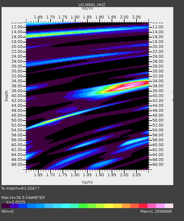
| Estimated Moho Depth: |
36.5 km |
| Estimated Crust Vp/Vs: |
2.00 |
| Assumed Crust Vp: |
6.566 km/s |
| Estimated Crust Vs: |
3.279 km/s |
| Estimated Crust Poisson's Ratio: |
0.33 |
|
| Radial Match: |
93.00677 % |
| Radial Bump: |
400 |
| Transverse Match: |
73.26677 % |
| Transverse Bump: |
400 |
| SOD ConfigId: |
20906531 |
| Insert Time: |
2020-04-08 15:20:54.564 +0000 |
| GWidth: |
2.5 |
| Max Bumps: |
400 |
| Tol: |
0.001 |
|

Signal To Noise
| Channel | StoN | STA | LTA |
| UO:MINN: :HHZ:20200325T02:57:51.617993Z | 22.758585 | 1.2799927E-5 | 5.624219E-7 |
| UO:MINN: :HHN:20200325T02:57:51.617993Z | 6.818142 | 3.3420883E-6 | 4.9017586E-7 |
| UO:MINN: :HHE:20200325T02:57:51.617993Z | 9.287138 | 5.003642E-6 | 5.3877113E-7 |
| Arrivals |
| Ps | 5.9 SECOND |
| PpPs | 16 SECOND |
| PsPs/PpSs | 22 SECOND |


