You are here: Home > Network List > UO - University of Oregon Regional Network Stations List
> Station PINE Pine Mountain Observatory, OR > Earthquake Result Viewer
PINE Pine Mountain Observatory, OR - Earthquake Result Viewer
| Earthquake location: |
East Of Kuril Islands |
| Earthquake latitude/longitude: |
49.0/157.7 |
| Earthquake time(UTC): |
2020/03/25 (085) 02:49:21 GMT |
| Earthquake Depth: |
57 km |
| Earthquake Magnitude: |
7.5 Mww |
| Earthquake Catalog/Contributor: |
NEIC PDE/us |
|
| Network: |
UO University of Oregon Regional Network |
| Station: |
PINE Pine Mountain Observatory, OR |
| Lat/Lon: |
43.79 N/120.94 W |
| Elevation: |
1916 m |
|
| Distance: |
53.8 deg |
| Az: |
62.514 deg |
| Baz: |
306.199 deg |
| Ray Param: |
0.065699674 |
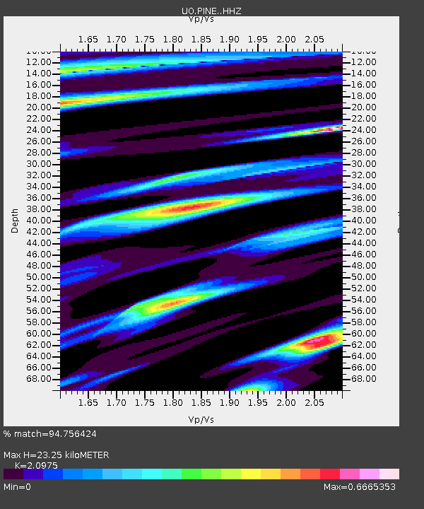
| Estimated Moho Depth: |
23.25 km |
| Estimated Crust Vp/Vs: |
2.10 |
| Assumed Crust Vp: |
6.597 km/s |
| Estimated Crust Vs: |
3.145 km/s |
| Estimated Crust Poisson's Ratio: |
0.35 |
|
| Radial Match: |
94.756424 % |
| Radial Bump: |
284 |
| Transverse Match: |
85.14084 % |
| Transverse Bump: |
400 |
| SOD ConfigId: |
20906531 |
| Insert Time: |
2020-04-08 15:21:03.478 +0000 |
| GWidth: |
2.5 |
| Max Bumps: |
400 |
| Tol: |
0.001 |
|

Signal To Noise
| Channel | StoN | STA | LTA |
| UO:PINE: :HHZ:20200325T02:58:07.649975Z | 35.481 | 1.0738913E-5 | 3.026666E-7 |
| UO:PINE: :HHN:20200325T02:58:07.649975Z | 8.368979 | 3.6151573E-6 | 4.3197107E-7 |
| UO:PINE: :HHE:20200325T02:58:07.649975Z | 12.787442 | 4.2491743E-6 | 3.3229276E-7 |
| Arrivals |
| Ps | 4.1 SECOND |
| PpPs | 10 SECOND |
| PsPs/PpSs | 14 SECOND |


