You are here: Home > Network List > UO - University of Oregon Regional Network Stations List
> Station SISQ Selma, OR, USA > Earthquake Result Viewer
SISQ Selma, OR, USA - Earthquake Result Viewer
| Earthquake location: |
East Of Kuril Islands |
| Earthquake latitude/longitude: |
49.0/157.7 |
| Earthquake time(UTC): |
2020/03/25 (085) 02:49:21 GMT |
| Earthquake Depth: |
57 km |
| Earthquake Magnitude: |
7.5 Mww |
| Earthquake Catalog/Contributor: |
NEIC PDE/us |
|
| Network: |
UO University of Oregon Regional Network |
| Station: |
SISQ Selma, OR, USA |
| Lat/Lon: |
42.28 N/123.63 W |
| Elevation: |
395 m |
|
| Distance: |
53.1 deg |
| Az: |
65.486 deg |
| Baz: |
306.138 deg |
| Ray Param: |
0.06618057 |
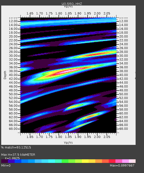
| Estimated Moho Depth: |
37.5 km |
| Estimated Crust Vp/Vs: |
1.86 |
| Assumed Crust Vp: |
6.522 km/s |
| Estimated Crust Vs: |
3.502 km/s |
| Estimated Crust Poisson's Ratio: |
0.30 |
|
| Radial Match: |
93.12515 % |
| Radial Bump: |
400 |
| Transverse Match: |
76.66695 % |
| Transverse Bump: |
400 |
| SOD ConfigId: |
20906531 |
| Insert Time: |
2020-04-08 15:21:06.902 +0000 |
| GWidth: |
2.5 |
| Max Bumps: |
400 |
| Tol: |
0.001 |
|

Signal To Noise
| Channel | StoN | STA | LTA |
| UO:SISQ: :HHZ:20200325T02:58:02.550Z | 22.425562 | 1.0084161E-5 | 4.496726E-7 |
| UO:SISQ: :HHN:20200325T02:58:02.550Z | 5.570318 | 2.773349E-6 | 4.978798E-7 |
| UO:SISQ: :HHE:20200325T02:58:02.550Z | 8.350509 | 3.4997583E-6 | 4.191072E-7 |
| Arrivals |
| Ps | 5.2 SECOND |
| PpPs | 16 SECOND |
| PsPs/PpSs | 21 SECOND |


