You are here: Home > Network List > US - United States National Seismic Network Stations List
> Station AMTX Amarillo, Texas, USA > Earthquake Result Viewer
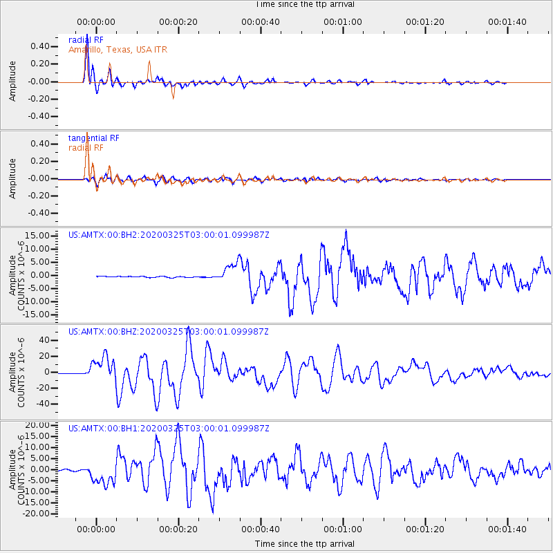
AMTX Amarillo, Texas, USA - Earthquake Result Viewer
*The percent match for this event was below the threshold and hence no stack was calculated.
| Earthquake location: |
East Of Kuril Islands |
| Earthquake latitude/longitude: |
49.0/157.7 |
| Earthquake time(UTC): |
2020/03/25 (085) 02:49:21 GMT |
| Earthquake Depth: |
57 km |
| Earthquake Magnitude: |
7.5 Mww |
| Earthquake Catalog/Contributor: |
NEIC PDE/us |
|
| Network: |
US United States National Seismic Network |
| Station: |
AMTX Amarillo, Texas, USA |
| Lat/Lon: |
34.53 N/101.41 W |
| Elevation: |
1010 m |
|
| Distance: |
71.2 deg |
| Az: |
58.895 deg |
| Baz: |
316.907 deg |
| Ray Param: |
$rayparam |
*The percent match for this event was below the threshold and hence was not used in the summary stack. |
|
| Radial Match: |
98.69684 % |
| Radial Bump: |
356 |
| Transverse Match: |
94.239044 % |
| Transverse Bump: |
400 |
| SOD ConfigId: |
20906531 |
| Insert Time: |
2020-04-08 15:21:24.365 +0000 |
| GWidth: |
2.5 |
| Max Bumps: |
400 |
| Tol: |
0.001 |
|
Signal To Noise
| Channel | StoN | STA | LTA |
| US:AMTX:00:BHZ:20200325T03:00:01.099987Z | 65.299484 | 1.6779582E-5 | 2.569635E-7 |
| US:AMTX:00:BH1:20200325T03:00:01.099987Z | 14.275438 | 5.3500376E-6 | 3.747722E-7 |
| US:AMTX:00:BH2:20200325T03:00:01.099987Z | 27.022058 | 5.0798712E-6 | 1.879898E-7 |
| Arrivals |
| Ps | |
| PpPs | |
| PsPs/PpSs | |


