You are here: Home > Network List > US - United States National Seismic Network Stations List
> Station BOZ Bozeman, Montana, USA > Earthquake Result Viewer
BOZ Bozeman, Montana, USA - Earthquake Result Viewer

| Earthquake location: |
East Of Kuril Islands |
| Earthquake latitude/longitude: |
49.0/157.7 |
| Earthquake time(UTC): |
2020/03/25 (085) 02:49:21 GMT |
| Earthquake Depth: |
57 km |
| Earthquake Magnitude: |
7.5 Mww |
| Earthquake Catalog/Contributor: |
NEIC PDE/us |
|
| Network: |
US United States National Seismic Network |
| Station: |
BOZ Bozeman, Montana, USA |
| Lat/Lon: |
45.65 N/111.63 W |
| Elevation: |
1589 m |
|
| Distance: |
57.9 deg |
| Az: |
55.854 deg |
| Baz: |
308.995 deg |
| Ray Param: |
0.063028574 |
| Estimated Moho Depth: |
34.25 km |
| Estimated Crust Vp/Vs: |
1.79 |
| Assumed Crust Vp: |
6.35 km/s |
| Estimated Crust Vs: |
3.543 km/s |
| Estimated Crust Poisson's Ratio: |
0.27 |
|
| Radial Match: |
98.892 % |
| Radial Bump: |
243 |
| Transverse Match: |
91.156296 % |
| Transverse Bump: |
400 |
| SOD ConfigId: |
20906531 |
| Insert Time: |
2020-04-08 15:21:29.545 +0000 |
| GWidth: |
2.5 |
| Max Bumps: |
400 |
| Tol: |
0.001 |
|
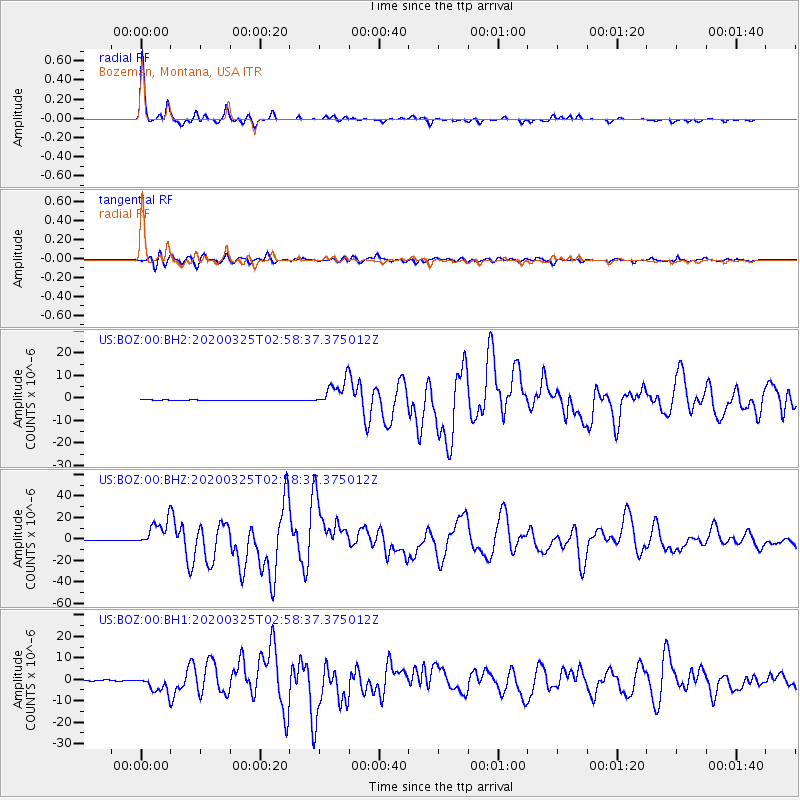
Signal To Noise
| Channel | StoN | STA | LTA |
| US:BOZ:00:BHZ:20200325T02:58:37.375012Z | 53.803932 | 1.2589984E-5 | 2.3399747E-7 |
| US:BOZ:00:BH1:20200325T02:58:37.375012Z | 18.777948 | 4.0828563E-6 | 2.1742825E-7 |
| US:BOZ:00:BH2:20200325T02:58:37.375012Z | 38.510124 | 5.238774E-6 | 1.3603628E-7 |
| Arrivals |
| Ps | 4.5 SECOND |
| PpPs | 14 SECOND |
| PsPs/PpSs | 19 SECOND |


