You are here: Home > Network List > US - United States National Seismic Network Stations List
> Station KSU1 Kansas State University--Konza Prairie, Kansas, USA > Earthquake Result Viewer
KSU1 Kansas State University--Konza Prairie, Kansas, USA - Earthquake Result Viewer
| Earthquake location: |
East Of Kuril Islands |
| Earthquake latitude/longitude: |
49.0/157.7 |
| Earthquake time(UTC): |
2020/03/25 (085) 02:49:21 GMT |
| Earthquake Depth: |
57 km |
| Earthquake Magnitude: |
7.5 Mww |
| Earthquake Catalog/Contributor: |
NEIC PDE/us |
|
| Network: |
US United States National Seismic Network |
| Station: |
KSU1 Kansas State University--Konza Prairie, Kansas, USA |
| Lat/Lon: |
39.10 N/96.61 W |
| Elevation: |
347 m |
|
| Distance: |
70.5 deg |
| Az: |
52.627 deg |
| Baz: |
317.717 deg |
| Ray Param: |
0.054839864 |
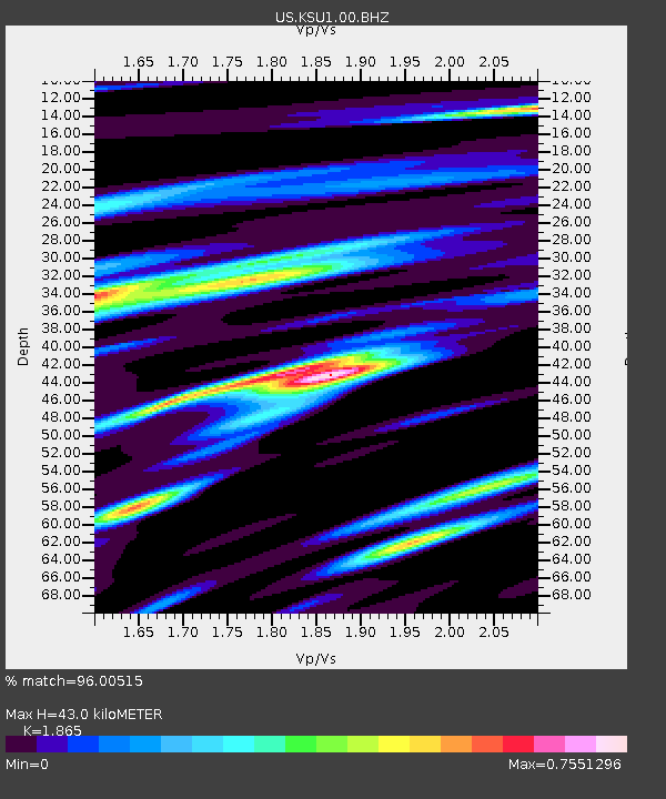
| Estimated Moho Depth: |
43.0 km |
| Estimated Crust Vp/Vs: |
1.87 |
| Assumed Crust Vp: |
6.483 km/s |
| Estimated Crust Vs: |
3.476 km/s |
| Estimated Crust Poisson's Ratio: |
0.30 |
|
| Radial Match: |
96.00515 % |
| Radial Bump: |
400 |
| Transverse Match: |
89.805756 % |
| Transverse Bump: |
400 |
| SOD ConfigId: |
20906531 |
| Insert Time: |
2020-04-08 15:21:58.481 +0000 |
| GWidth: |
2.5 |
| Max Bumps: |
400 |
| Tol: |
0.001 |
|

Signal To Noise
| Channel | StoN | STA | LTA |
| US:KSU1:00:BHZ:20200325T02:59:59.099011Z | 45.412704 | 1.1947675E-5 | 2.63091E-7 |
| US:KSU1:00:BH1:20200325T02:59:59.099011Z | 17.859735 | 5.280712E-6 | 2.9567693E-7 |
| US:KSU1:00:BH2:20200325T02:59:59.099011Z | 3.8223324 | 6.0370706E-7 | 1.5794207E-7 |
| Arrivals |
| Ps | 5.9 SECOND |
| PpPs | 18 SECOND |
| PsPs/PpSs | 24 SECOND |


